Catalog Archive
Auction 159, Lot 401

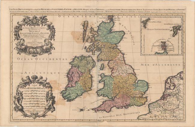
"Les Isles Britanniques; qui Contiennent les-Royaumes, d'Angleterre, Escosse, et Irlande...", Sanson/Jaillot

Subject: Britain

Period: 1692 (dated)

Publication:

Color: Hand Color

Size:
34.6 x 21.6 inches
87.9 x 54.9 cm
Download High Resolution Image
(or just click on image to launch the Zoom viewer)

This is considered one of the most attractive maps of the British Isles of the late 17th century. The map was created by Jaillot, who was the successor to the Sanson publishing family. The map follows the geography of Nicolas Sanson, who is credited in the title cartouche along with Charles Saxton, John Speed, and Timothy Pont, among others. Britain is shown in fine detail with hundreds of place names in this finely engraved map. The map has two stunning baroque cartouches featuring Neptune, angels, horses with their handlers, and cherubs with large dogs. A large inset details the Shetland, Faroe and Orkney Islands. This is the second plate, second state with the addition of lines of longitude and latitude. An alternate French title appears above the map: "Les Isles Britanniques, ou Sont les Royaumes d'Angleterre, d'Ecosse, et d'Irlande; Distingues en leurs Provinces..." Printed on two sheets, joined as issued.

References: Shirley (BI to 1750) Jaillot 1, Plate 2.2.

Condition: B

A dark, crisp impression with full, original color and moderate color offsetting. There is a short centerfold separation at bottom, a small hole in the North Sea, and two chips in bottom blank margin that have been repaired with old paper, with loss of a minor amount of neatline.

Estimate: $700 - $850

Sold for: $500

Closed on 9/14/2016

Archived