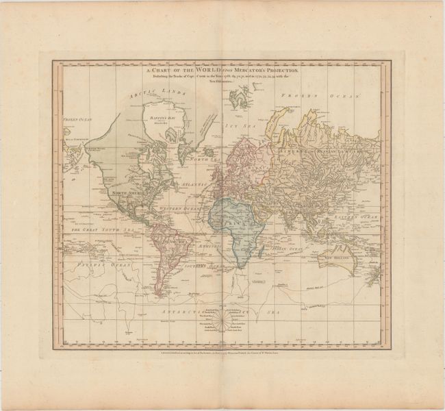
"A Chart of the World upon Mercator's Projection. Describing the Tracks of Capt. Cook in the Years 1768, 69, 70, 71, and in 1772, 73, 74, 75, with the New Discoveries", Jefferys & Faden
Subject: World
Period: 1775 (dated)
Publication: Geographical Exercises; Calculated to Facilitate the Study of Geography
Color: Hand Color
Size:
17.9 x 15.4 inches
45.5 x 39.1 cm
Thomas Jefferys was one of the most important English map publishers of the 18th century. His work included prints and maps of locations around the world, but his most notable maps are of North America and the West Indies. He began his career in the map trade in the early 1730s, working as an engraver for a variety of London publishers, and eventually setting up his own shop. In 1746, he was appointed Geographer to the Prince of Wales, and in 1760 he became Geographer to the King. These titles granted access to manuscripts and cartographic information held by the government. In the early 1760s he embarked on an ambitious project to produce a series of English county maps based on new surveys, but ran out of money and filed for bankruptcy in 1766. He then partnered with London publisher Robert Sayer, who reissued many of Jefferys plates and continued to issue new editions after Jefferys' death in 1771. Jefferys' American Atlas and the accompanying West-India Atlas, published post posthumously, are considered his most important cartographic works.
This interesting chart of the world presented on Mercator's projection details the discoveries made during Captain Cook's first two expeditions. New Zealand and many of the islands in the south Pacific Ocean are well defined, and there are a number of place names on the eastern coast of Australia, here called New Holland. In North America there is a dotted line to denote the River of the West. The northwest coastline continues with notations of Juan de Fuca's "entrance" and Admiral de Fonte's "pretended entrance." Alaschka is a large island in the Bering Strait. A handful of cities are noted in North America, including Santa Fe, which is located nearly as far north as Cape Mendocino. Several Indian tribes are located in present-day US, with Eskimos located in Canada. An interesting and very uncommon map of the world.
References: Shirley (BL Atlases) T.FAD-1a #9.
Condition: B+
Full original color on watermarked paper with wide margins. Thee is mild toning, faint offsetting, and a few small spots.