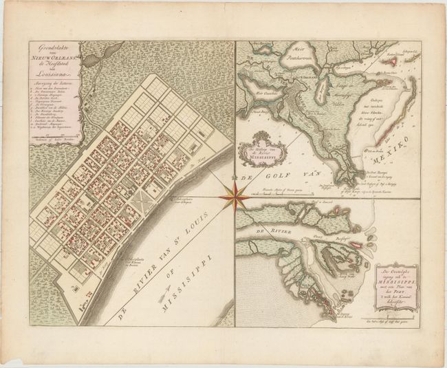
"Grondvlakte van Nieuw Orleans, de Hoofdstad van Louisiana [on sheet with] De Uitloop van de Rivier Missisippi [and] De Oostelyke Ingang van de Missisippi, met een Plan van het Fort; 't Welk het Kanaal Beheerscht", Tirion, Isaac
Subject: New Orleans, Louisiana
Period: 1769 (circa)
Publication: Hedendaagsche Historie van Amerika...
Color: Hand Color
Size:
17.6 x 13 inches
44.7 x 33 cm
This handsome sheet consists of three maps composed around a large compass rose. It is Tirion's version of the map first drawn by De la Tour in 1720, only two years after the founding of New Orleans. The first map is a plan of the city of New Orleans (now the French Quarter) vividly depicting its protective canal, barracks, and quays. The second is a map of the vicinity of New Orleans including the delta and surrounding bayou. The third is a map of the location of Fort la Balisle at the mouth of the river, which sank into the marsh in the late 1700's. Each map has a delicately engraved title cartouche, and a lovely compass rose connects all three maps.
References: Goss (NA) #63; Shirley (BL Atlases) G.TIR-1a #22; cf. Van Ermen #39.
Condition: A
On watermarked paper with a small chip at bottom left and a few short edge tears that have been repaired with archival materials on verso, all confined to the blank margins.