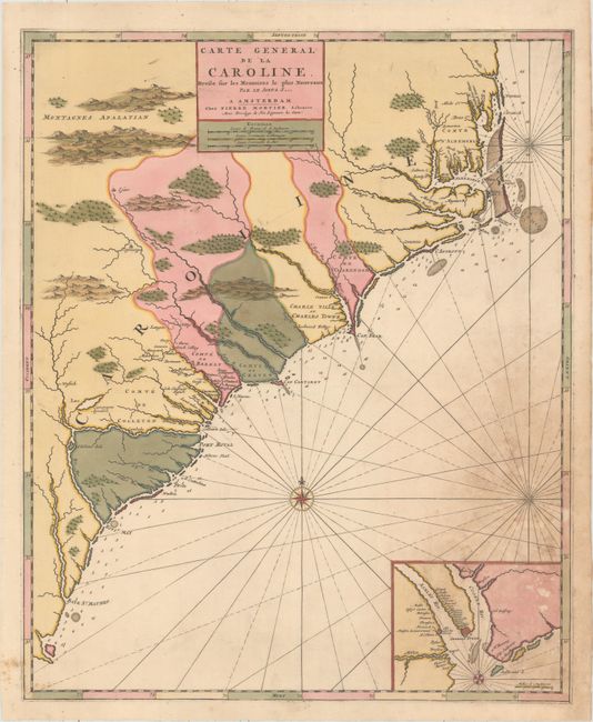
The First Map of the Carolinas Published Outside of England
"Carte General de la Caroline. Dresse sur les Memoires le Plus Nouveaux par le Sieua S...", Mortier, Pierre
Subject: Colonial Southeast United States
Period: 1700 (circa)
Publication: Suite de Neptune Francois
Color: Hand Color
Size:
18.3 x 22.4 inches
46.5 x 56.9 cm
This map depicts present-day North and South Carolina, and was the first map of the Carolinas published outside of England. Despite the title giving credit to Nicolas Sanson, it was derived from Thornton, Morden and Lea's map of 1685 with very few changes. The subtle modifications include place names translated into French, and a previous key naming various plantations around Charleston was replaced with the title cartouche. Cartographically, the map shows good coastal detail, displaying numerous soundings and shoals, as well as inland detail of towns, cities, and mountains in profile. At bottom right is an inset of Charleston surrounded by the Ashley and Cooper Rivers, naming many plantations in the area. Decorated by a compass rose and rhumb lines. First state of the map with the imprint of Pierre Mortier.
References: Burden #767; Cumming (SE) #120.
Condition: B
Full original color with a few short cracks that have been closed on verso with archival material and a crease at right with a resulting 1" separation that has also been closed with archival material. There is a large damp stain at bottom right, resulting in a few small abrasions, that has been professionally reinforced on verso with old paper.