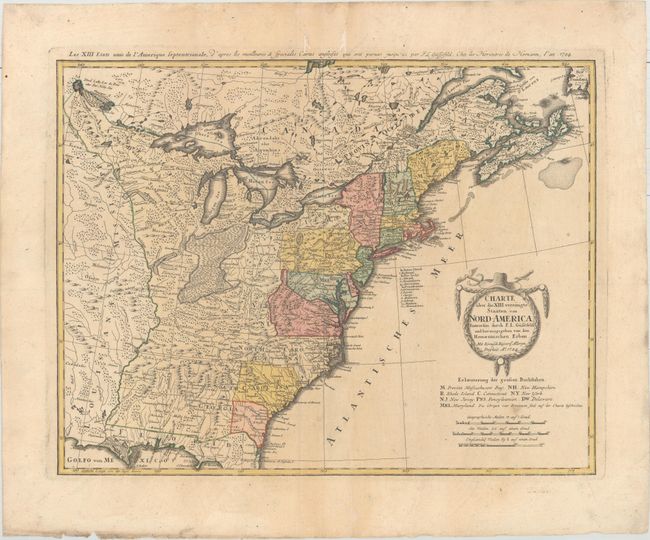
"Charte uber die XIII Vereinigte Staaten von Nord-America...", Gussefeld/Homann Heirs
Subject: Eastern United States
Period: 1784 (dated)
Publication:
Color: Hand Color
Size:
22.9 x 17.8 inches
58.2 x 45.2 cm
This very early and under-appreciated German map of the newly formed United States of America delineates nine of the newly formed states. The map extends west past the Mississippi River and north to the southern tip of Hudson Bay, but the focus of the map is on the United States. The southern states are shown with their western boundaries on the Mississippi River, although the coloring shows only regions east of the Appalachians as being organized. The lands to the West of the Mississippi River are labeled as either Louisiana or Mississippi. A note in Kentucky locates Walker's Establishment in 1750, Massachusetts here is the Province of Massachusetts Bay, and neither Maine or Vermont have been organized. As with many German maps of the period, there are some incorrect state boundaries; Vermont is shown as part of New Hampshire, and Maryland includes much of northern Virginia. Principal German communities in New York, New Jersey, and Pennsylvania are listed. The interior regions are shown with considerable topographical detail, locating numerous Indian tribes and watershed. The uncolored, as issued, garland-style title cartouche is topped with a hat and crossed swords. The French title is outside the top neatline: Les XIII Etats Unis de l' Amerique Septentrionale…
References: McCorkle #784-7; Sellers & Van Ee #757.
Condition: B+
On a watermarked sheet with light toning and a few worm tracks in the blank margins, the longest of which have been closed on verso with archival material. There is marginal soiling and some small chips and tears along the sheet's bottom edge.