Catalog Archive
Auction 158, Lot 267

Rare and Early Sea Chart of the Southeastern Coast of Sweden

"De Custen van een deel van Denemarken en Swederijck, Beginnede va Vuijtste to Calmer Toe...", Waghenaer, Lucas Jansz

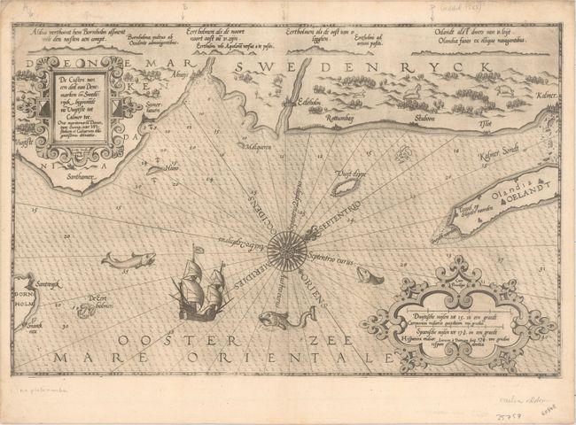
Subject: Southeastern Sweden

Period: 1585 (circa)

Publication: Spieghel der Zeevaerdt

Color: Black & White

Size:
20.3 x 13 inches
51.6 x 33 cm
Download High Resolution Image
(or just click on image to launch the Zoom viewer)

A very early sea chart covering the southeastern coast of Sweden from Sandhammaren to Kalmer, including portions of the islands of Bornholm and Oland. There is a wealth of detail including soundings, sandbars, anchorages, towns, and coastal topography. A large sailing ship and several sea monsters fill the waters, while a fox, goat and pig roam the land. The map is centered on a 32-point compass rose with north oriented to the top right corner, and is further adorned with two large decorative cartouches. The map is from the Spieghel der Zeevaerdt, the first detailed atlas of charts covering the coastlines of Europe. The map is elaborately embellished with two large strapwork cartouches, extravagant sea monsters, and two sailing ships. Waghenaer's charts are renowned for their fine engraving by the best craftsmen of the period including Theodore de Bry and the Doetecum brothers. This map was engraved by Joannes Doetecum, whose imprint appears below the distance scales. Latin text on verso.

References: Shirley (BL Atlases) M.WAG-1a.

Condition: A

On a sturdy sheet with light printer's ink residue, a minor crease adjacent to centerfold, and a couple of tiny holes only visible when held to light.

Estimate: $1,400 - $1,700

Sold for: $1,000

Closed on 6/22/2016

Archived