Catalog Archive
Auction 158, Lot 115

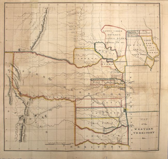
"Map of the Western Territory &c. [in report]", Hood, Washington (Lt.)

Subject: Central United States

Period: 1834 (published)

Publication: HR Report 474, 23rd Congress. 1st Session

Color: Hand Color

Size:
17.7 x 17 inches
45 x 43.2 cm
Download High Resolution Image
(or just click on image to launch the Zoom viewer)

This important early map of the Indian Territories covers the region between the Yellowstone River and Santa Fe east to Fort Armstrong on the Mississippi River and Fort Smith on the Arkansas River. It is the first government map to collectively show the boundaries of the various Indian lands and land cessions west of the Mississippi. Named Indians lands and cessions include Choctaws, Seminoles, Creeks, Cherokees, Osages, and Senecas. The map is accompanied by Horace Everett’s important report (131 pages) that provided regulated trade and intercourse with the Indians and established the Western Territory providing security and protection for emigrants and the Indian tribes therein. It accompanied three House bills (Nos. 488, 489 & 490) that provided for the organization of the Dept. of Indian Affairs.

References: Wheat (TMW) #405; Claussen & Friis #32; Howes #E235; Wagner-Camp #49.

Condition: B

Light to moderate offsetting with three fold separations that enter the image approximately 1.5 to 2.5". Another closed separation at the top of the sheet has been closed on recto with archival tape. Disbound text is very good with light toning.

Estimate: $450 - $550

Sold for: $375

Closed on 6/22/2016

Archived