Catalog Archive
Auction 158, Lot 107

The First Map of the Carolinas Published Outside of England

"Carte General de la Caroline Dresse sur les Memoires le Plus Nouveaux...", Mortier, Pierre

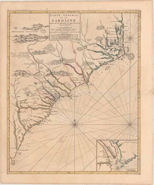
Subject: Colonial Southeastern, North Carolina, South Carolina

Period: 1700 (circa)

Publication: Suite de Neptune Francois

Color: Hand Color

Size:
18.3 x 22.2 inches
46.5 x 56.4 cm
Download High Resolution Image
(or just click on image to launch the Zoom viewer)

This map depicts present-day North and South Carolina, and was the first map of the Carolinas published outside of England. Despite the title giving credit to Nicolas Sanson, it was derived from Thornton, Morden and Lea's map of 1685 with very few changes. The subtle modifications include place names translated into French, and a previous key naming various plantations around Charleston was replaced with the title cartouche. Cartographically, the map shows good coastal detail, displaying numerous soundings and shoals, as well as inland detail of towns, cities, and mountains in profile. At bottom right is an inset of Charleston surrounded by the Ashley and Cooper Rivers, naming many plantations in the area. Decorated by a compass rose and rhumb lines. First state of the map with the imprint of Pierre Mortier.

References: Burden #767; Cumming (SE) #120.

Condition: B+

Original outline color with light offsetting and a few minor spots.

Estimate: $3,000 - $3,750

Sold for: $2,000

Closed on 6/22/2016

Archived