Catalog Archive
Auction 157, Lot 378

Van Keulen's Stunning Chart of Cuba and the Southeast Coast of Florida

"Pas Kaart vande Noord Oost Kust van Cuba en d'Oost Kust van Florida Vervaatende de Canal van Bahama met de Bahaamse Eylanden...", Keulen, Johannes van

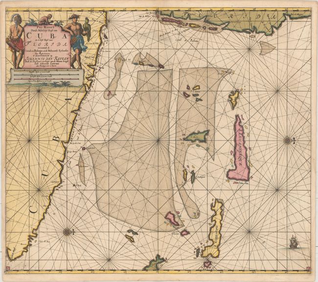
Subject: Cuba, Southeastern Florida, Bahamas

Period: 1695 (circa)

Publication:

Color: Hand Color

Size:
23.1 x 20.3 inches
58.7 x 51.6 cm
Download High Resolution Image
(or just click on image to launch the Zoom viewer)

This is the third state of this chart, with the page number appearing in both lower corners of the chart. It shows the northeastern coast of Cuba, the southeastern coast of Florida, most of the Keys, and many islands of the Bahamas. The cartography is based on Arent Roggeveen's Pascaerte Van 't Canael de Bahama (1675), the only printed chart of the region on a similar scale, and a rare Hessel Gerritz chart. Van Keulen's work departs from its sources in its expansion of the area that Cuba is depicted, its elimination of some of the Keys, and the addition of Cajo de Melchior Roiz in Florida. Place names appear along the coasts, including Cape Canaveral (Cabo de Canaveral) and Key Biscayne (Cayo de Biscambos). Two compass roses orient the north to the right, and a sailing ship decorates the ocean. In the top left corner is a large and opulent title cartouche featuring a monkey and two natives with quivers, with a parrot perched upon one native's arm. The map appeared concurrently in both van Keulen's Zee-Fakkel and his Zee-Atlas.

References: Burden #590.

Condition: A

A dark impression that has been backed with a sheet of sturdy paper. There is a faint damp stain at left, minor soiling and a bit of printer's ink residue.

Estimate: $3,250 - $4,000

Unsold

Closed on 5/4/2016

Archived