Catalog Archive
Auction 157, Lot 336

"York Town, and Gloucester Point. As Besieged by The Allied Army", Conder, Thomas

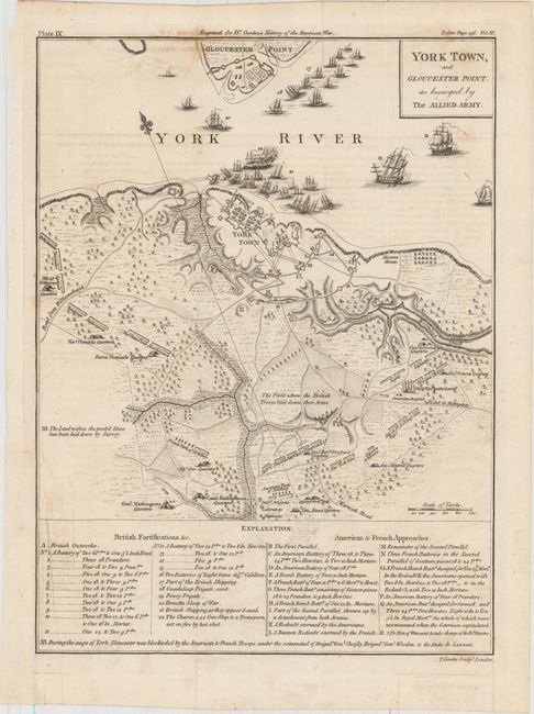
Subject: Yorktown, Virginia

Period: 1788 (circa)

Publication: The History of Rise, Progress and Establishment of the…United States

Color: Black & White

Size:
8.5 x 11.3 inches
21.6 x 28.7 cm
Download High Resolution Image
(or just click on image to launch the Zoom viewer)

This finely engraved map provides information on this important American Revolutionary War battle including the positions of British, American and French troops, and the ships in the York River. Good detail including many villages, roads, watershed, forests, and topographical information. Locates with tent icons the quarters of Count Rochambeau, Gen. Washington, Gen. Knox, Gen. Nelson, Gen. Clinton, and several French commanders. Names Moore's House and delineates the roads to Williamsburg and to Hampton. The lower quarter of the map is a key that names and locates 22 British Fortifications and 15 French and American "Approaches". North located by a fleur-de-lis in the York River. Plate IX at upper left above neatline. Published in William Gordon's The History of Rise, Progress and Establishment of the Independence of the United States.

References: Howes #G256.

Condition: B+

Issued folding and now flattened with faint offsetting. There is a binding trim at lower left and an associated short binding tear that has been closed on verso with archival material.

Estimate: $350 - $425

Sold for: $325

Closed on 5/4/2016

Archived