Catalog Archive
Auction 157, Lot 325

"General Map of Charleston Harbor South Carolina Showing Rebel Defenses and Obstructions", U.S. War Department

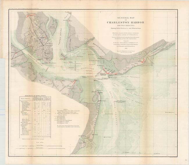
Subject: Charleston, South Carolina

Period: 1865 (dated)

Publication: Annual Report of the Secretary of the Navy

Color: Printed Color

Size:
24.5 x 21.5 inches
62.2 x 54.6 cm
Download High Resolution Image
(or just click on image to launch the Zoom viewer)

This fascinating map was produced under the direction of Rear Admiral J.A. Dahlgren U.S.N. commanding South Atlantic Blockading Squadron, by C.O. Boutelle Asst. U.S. Coast Survey. It shows the surveys of the shore line, channels, and fortifications with the location of Union and Rebel Batteries shown in color. It details positions of shipwrecks, obstructions, and torpedoes including the Housatonic, Keokuk, Flamingo, and many more. Tracks of numerous torpedoes are detailed. Many interesting notes include one giving the position of Ironsides as it lay over a 2,000 pound torpedo for "one hour" on April 7th, 1863. Table at lower left, Armament of Rebel Forts and notes explain the various symbols on the map. Charleston is shown as a detailed street grid. Possibly the best chart of Charleston Harbor produced during the Civil War. Extends to include Forts Shaw, Marshall, Sumter, Wagner and Johnson, plus many batteries.

References:

Condition: B+

Issued folding with light toning along the folds and faint offsetting of text in a few blank areas of the sheet. There is a 1.5" binding tear at upper left that has been closed on verso with archival material. Professionally backed in light tissue.

Estimate: $275 - $350

Sold for: $200

Closed on 5/4/2016

Archived