Catalog Archive
Auction 157, Lot 223

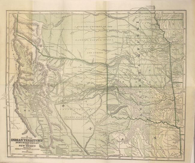
"A Map of the Indian Territory Northern Texas and New Mexico Showing the Great Western Prairies [bound in] Commerce of the Prairies...Vol. I", Gregg, Josiah

Subject: South-Central United States, Indian Territory

Period: 1844 (published)

Publication:

Color: Printed Color

Size:
15.5 x 12.8 inches
39.4 x 32.5 cm
Download High Resolution Image
(or just click on image to launch the Zoom viewer)

Wheat describes this as a "cartographic landmark" of the western territories and covers the area from Missouri, Kansas and Louisiana to the Rocky Mountains. It is the first edition, published just before the more common Morse and Breese atlas map, also dated 1844, but published in 1845. The map shows the northern part of the Republic of Texas reaching along the Rockies and has quite a bit of Indian Territory as well. New Mexico is shown, with Santa Fe as the destination of the route of the Santa Fe Caravans. The map has many tracks of explorers and other routes shown, with topography, towns, villages, smaller villages and ranches, Indian villages, forts, trading posts, ruins, springs, and camps. This would have been a very valuable map for anyone considering traveling across the prairie in the mid 19th century. The map is still bound into the first volume of the work which includes 320 pages and 3 plates. Hardbound in brown cloth with gilt illustration on front cover and gilt title on spine.

Josiah Gregg first went west in the 1830's to look for a cure for his tuberculosis. He recovered his health and traveled across the prairies as a merchant to Santa Fe, Texas and Mexico.

References: Wheat (TMW) #482; Wagner & Camp #108.1; Howes #G401.

Condition: A

The map is near fine with some faint toning at left and a short edge tear confined to the right blank margin. Text is clean and tight while plates have scattered foxing. Light wear to extremities.

Estimate: $700 - $900

Sold for: $750

Closed on 5/4/2016

Archived