Catalog Archive
Auction 156, Lot 81

Rare First State with California as an Island

"Amerique Septentrionale Divisee en ses Principales Parties", Sanson/Jaillot

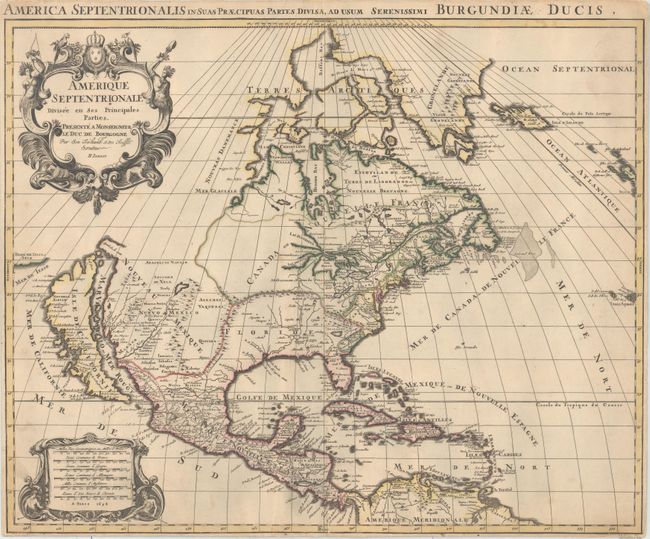
Subject: North America

Period: 1694 (dated)

Publication: Atlas Royal

Color: Hand Color

Size:
22.9 x 18.4 inches
58.2 x 46.7 cm
Download High Resolution Image
(or just click on image to launch the Zoom viewer)

First state of this handsome map showing the island of California with an indented northern coast and the Terre de Iesso Ieco (Japan) just a short distance off its northwestern coast. All five Great Lakes are now shown, with Superior and Michigan open-ended. The Rio del Norte flows incorrectly into the Gulf of California. The lion's share of today's United States is divided between Floride and Nouveau Mexique. The region of present-day South Carolina and Georgia is noted as Floride Francoise. The decorative title cartouche is adorned with the French coat of arms, two Native Americans and tropical birds. The Latin title in upper margin is: "America septentrionalis in suas praecipuas partes divisa, ad usum serenissimi Burgundiae Ducis." Jaillot published a similar map with the same title that is much more commonly found on the market.

References: Burden #700; McLaughlin #113; Wheat (TMW) #74.

Condition: B+

A fine impression with original outline color on double-thick paper. There is minor soiling, some extraneous creasing, and a few tiny abrasions along one of the creases. The margins are narrow but adequate. The faint blue shadows that appear along the centerfold and at bottom left are caused by our scanner and do not appear on the map itself.

Estimate: $2,400 - $3,000

Sold for: $2,200

Closed on 2/17/2016

Archived