Catalog Archive
Auction 156, Lot 769

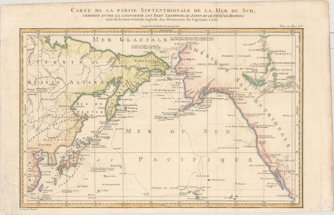
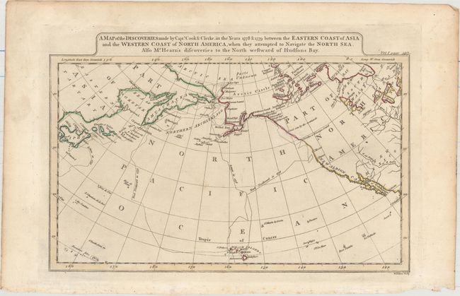
"[Lot of 2] Carte de la Partie Septentrionale de la Mer du Sud, Comprise Entre la Californie, les Isles Sandwich, le Japon et le Detrt. de Behring... [and] A Map of the Discoveries Made by Capts. Cook & Clerke in the Years 1778 & 1779...",

Subject: North Pacific Ocean

Period: 1782-1800 (circa)

Publication:

Color: Hand Color

Size:
See Description
Download High Resolution Image
(or just click on image to launch the Zoom viewer)

Captain James Cook (1728-1779) is best known for his three voyages to the Pacific (1768-71; 1772-75; and 1776-79). His discoveries radically changed the western understanding of the world in the late 18th century. He was the first to circumnavigate and chart New Zealand and provided the earliest European accounts of exploration along the eastern coast of Australia and the Hawaiian Islands. On February 14th, 1779, he was killed on Hawaii after attempting to kidnap the chief of the island.

Many contemporary accounts of Cook’s voyages, including charts and engravings, appeared in the late 18th century. The first official account of Cook’s first voyage was published in 1773 by John Hawkesworth in Volumes II and III of An Account of the Voyages Undertaken by the Order of His Present Majesty for Making Discoveries in the Southern Hemisphere... William Strahan and Thomas Cadell published the first official accounts of the second and third voyages in 1777 and 1784. Accounts of his exploration were subsequently translated into French, German, and Dutch.

A. Carte de la Partie Septentrionale de la Mer du Sud, Comprise Entre la Californie, les Isles Sandwich, le Japon et le Detrt. de Behring..., by Jacques Nicolas Bellin, from Prevost's Histoire Generale des Voyages, circa 1782 (14.5 x 9.3"). This fine map is based on the Henry Roberts/Cook chart with the addition of China, Japan, and the Sandwich Islands. It details the adjacent coastal areas of Russian Asia from the Bering Strait and the Kamchatka Peninsula down to Japan, Korea, and China, and across to the west coast of North America down to below the Baja Peninsula. The interior of the Northwest is completely blank, but details are beginning to emerge along the coastal areas as the maps names R. De Cook, Port De Norton, the B. De Bristol, Ounalachka, and more. Shows the tracks of Capt. Cook's ships, the Resolution and the Discovery, during Cook's third voyage to the Pacific between 1778 and 1789. Cook traveled from the Sandwich Islands to Nootka and the southern coast of Alaska, where he surveyed Prince William Sound and the Aleutian Islands. He then continued northward through the Bering Strait to the Arctic above the 70th parallel before weather and ice forced his return to the Sandwich Islands. The map features lakes, rivers, mountains and other geographical features. Finely engraved by Dupuis. An uncommon Cook map. Condition: Issued folding, now flat, with minor offsetting and a couple archivally repaired edge tears in the blank margins at bottom left. (A)

B. A Map of the Discoveries Made by Capts. Cook & Clerke in the Years 1778 & 1779 Between the Eastern Coast of Asia and the Western Coast of North America..., by John Payne, from Universal Geography..., circa 1800 (11.3 x 7.5"). This chart details the track of the explorations of Captain Cook in 1778 & 1779 including the ill fated stop in Hawaii, here called the Sandwich Islands. It covers the area from eastern Asia and Japan to California. The Aleutian chain is labeled the Northern Archipelago. Dotted lines show the routes traveled by the explorers. Engraved by William Palmer. Reference: McCorkle (18th C. Geography Books) #325-12. Condition: A crisp impression with some minor spots and an unobtrusive hole in southern Canada that has been repaired with archival materials. (B+)

References:

Condition:

See description above.

Estimate: $200 - $240

Sold for: $115

Closed on 2/17/2016

Archived