Catalog Archive
Auction 156, Lot 768

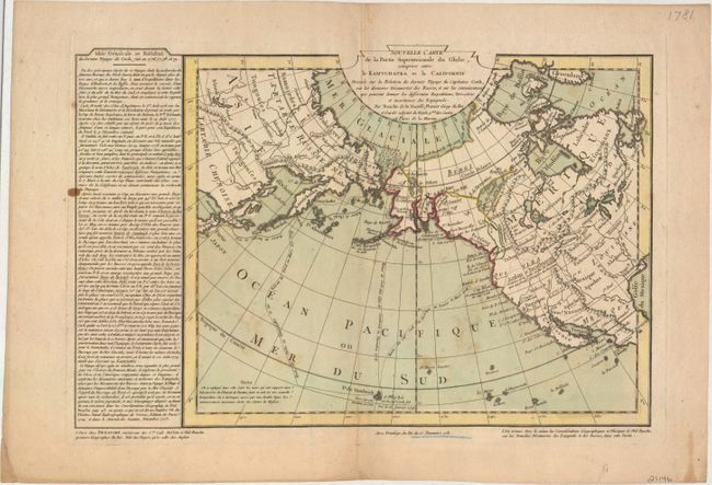
"Nouvelle Carte de la Partie Septentrionale du Globe, Comprise Entre le Kamtchatka et la Californie...", Buache/Dezauche

Subject: North Pacific Ocean

Period: 1781 (dated)

Publication:

Color: Hand Color

Size:
15.7 x 10.4 inches
39.9 x 26.4 cm
Download High Resolution Image
(or just click on image to launch the Zoom viewer)

This handsome small map is centered on the North Pacific Ocean and extends to show the majority of North America. The map was created to reconcile Juan de Fuca and Admiral de Fonte's discoveries with Captain Cook's third voyage (1776-79) through the North Pacific Ocean. A small remnant of the Sea of the West, which had long been championed by Philippe Buache, appears between Qui and Vira. Further north there is a large lake named Lac de Fuentes, which nearly connects the Pacific Ocean to Hudson Bay. Cook's route is depicted, and a block of text at left describes his voyage. This map is quite rare and was published in the memoir of Jean Nicholas Buache de la Neuville, who was Philippe Buache's nephew.

This map is accompanied by a receipt signed by Jean Nicholas Buache.

References: Falk #1781-5; McGuirk #177; Tooley (America) p. 37, #112; Wagner #677.

Condition: B+

Original color on watermarked paper with a few spots of foxing and two minute holes in image, only visible when held to light.

Estimate: $700 - $850

Unsold

Closed on 2/17/2016

Archived