Catalog Archive
Auction 156, Lot 762

The Earliest Printed Map to Focus on the North Pacific

"Tartariae sive Magni Chami Regni Typus", Ortelius, Abraham

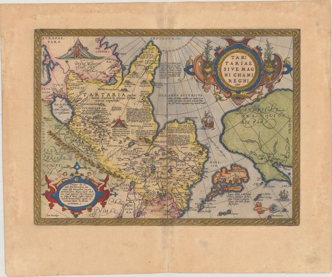
Subject: North Pacific, Northern Asia & Northwestern North America

Period: 1608 (circa)

Publication: Theatrum Orbis Terrarum

Color: Hand Color

Size:
18.6 x 13.9 inches
47.2 x 35.3 cm
Download High Resolution Image
(or just click on image to launch the Zoom viewer)

This extremely decorative map is important for several reasons and therefore becomes a foundation map for a variety of collection subjects.

It is the earliest printed map to focus on the North Pacific and the Stretto di Anian. Ortelius' depiction increased public awareness of Gastaldi's theory of a strait between the continents of Asia and America. It also includes a very early depiction of Japan, which is shown as a huge group of islands taking up nearly the entire North Pacific and located equal distance from both Asia and America. A notation reveals that Japan, called Zipangri by Marco Polo and also Chryse, was once attacked by the great Khan.

It is also one of the earliest (obtainable) maps to depict Northwestern America and to name California (C. Califormio). Six of the mythical Seven Cities of Cibola are located in the present-day Southwestern United States. This information was derived from reports of the ill-fated expedition of Francisco Vasquez de Coronado in 1541.

The map was designed to illustrate the expansive Kingdom of the Great Khan in Asia, which according to Ortelius is bounded by the river Ob, Lake Kataia, the Volga, the Caspian Sea, the river Chesel, the mountains of Usson, the area of Tibet, the river Caromora and the Morning Ocean.

The map was beautifully engraved by Frans Hogenberg and is filled with decoration including two encampments of Tartars, sailing ships, a flying fish and two elaborate strapwork cartouches. This is the third state with Italian text on verso indicating it was published in either 1608 or 1612.

References: Burden #41; Van den Broecke #163.3; Wagner (NW) #81; Wheat (TMW) #16; Walter #11E.

Condition: B+

Attractive color and wide margins with light toning along the centerfold, two spots in the map, and a professionally repaired 1/2" tear adjacent to the centerfold near the bottom of the map.

Estimate: $1,600 - $1,900

Sold for: $800

Closed on 2/17/2016

Archived