Catalog Archive
Auction 156, Lot 70

De Wit's Uncommon Carte-a-Figures Map of the Americas

"Nova Totius Americae Descriptio", Wit, Frederick de

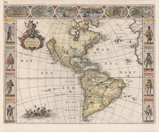
Subject: Western Hemisphere - America

Period: 1660 (dated)

Publication:

Color: Hand Color

Size:
22 x 17.4 inches
55.9 x 44.2 cm
Download High Resolution Image
(or just click on image to launch the Zoom viewer)

An uncommon and splendid carte-a-figures map of the Americas. The map combines many different sources including the Luke Foxe model of the island of California. The only hint of the Great Lakes is a small L. Contenant at the end of the St. Lawrence River. Nieu Neder Land occupies the eastern seaboard and there is no mention of any English settlement other than the name Virginia. In South America a large river and lake system provides the boundary of Brazil, with the mythical lake Eupana Lacus. A second mythical lake, Parime Lacus, is shown along the equator. The decorations were taken from van den Keere's map of 1614. The figures at sides depict the natives of Virginia, Magellanica, and Brazil, and the cities across the top include Cusco, Mexico, Olinda, Havana, S. Dominique, and Cartegena. The map is further embellished with a title cartouche bearing a native Indian mounted on an armadillo, and Neptune frolicking in the Pacific with mermaids and sea horses. This is the first state of this separately issued map.

References: Burden #356; McLaughlin #24; Tooley (America) #18.

Condition: A

A crisp impression with attractive color and minor printer's ink residue. Short centerfold separations at top and bottom have been professionally repaired, and the left and right margins have been extended to accommodate framing.

Estimate: $4,500 - $5,500

Sold for: $3,250

Closed on 2/17/2016

Archived