Catalog Archive
Auction 156, Lot 305

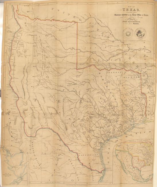
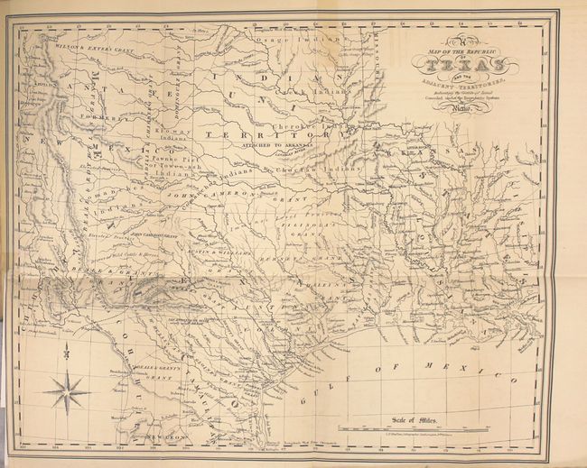
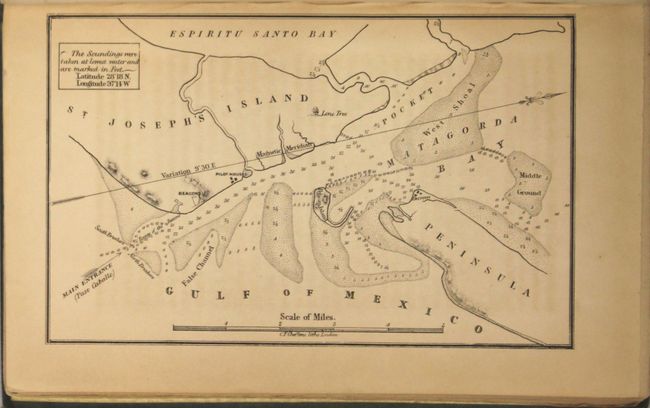
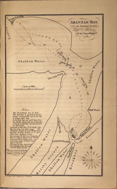
Arrowsmith's Important Map of the Republic of Texas with Kennedy's Book

"Map of Texas, Compiled from Surveys Recorded in the Land Office of Texas, and other Official Surveys [bound in] Texas: The Rise, Progress, and Prospects of the Republic of Texas", Arrowsmith, John

Subject: Texas

Period: 1841 (dated)

Publication:

Color: Hand Color

Size:
19.8 x 24 inches
50.3 x 61 cm
Download High Resolution Image
(or just click on image to launch the Zoom viewer)

The Republic of Texas was a sovereign state in North America from 1836 to 1845. It was formed as a break-away republic from Mexico by the Texas Revolution. The nation claimed a large region that included all of the present state of Texas together with part of the former Mexican region of New Mexico (parts of present-day New Mexico, Oklahoma, Kansas, Colorado, and Wyoming). The eastern boundary with the United States was defined by the Adams-Onís Treaty between the United States and Spain, in 1819. Its southern and western-most boundary with Mexico was under dispute throughout the existence of the republic, with Texas claiming that the boundary was the Rio Grande, and Mexico claiming the Nueces River as the boundary.

This is the second edition of this scarce and important map of the Republic of Texas, published only two months after the first edition. Arrowsmith's map was likely the first to show the full extent of Texas' claim to the upper Rio Grande valley, an area that would remain a part of Texas until the Compromise of 1850. It is also one of the earliest maps to contain information from the General Land Office of Texas with the delineation of pioneer county development and land grants, including those for Castro, Kennedy, Pierson, Fisher and Bourgeois d'Orvanne. The map provides an accurate depiction of boundaries, river systems, Indian tribes, and major roads. The many details include the Waggon Rd. to Santa Fe, the Presidio Road, the Commanche Road, and the road to the Red River, which included along its way a Sick Camp and the grave of General Leavenworth. The arid western region purportedly explored by Le Grand in 1833 contains a note that the expansive area is naturally fertile well wooded & with a fair proportion of water; an erroneous remark that appears in this region on maps throughout much of the nineteenth century. This region is embellished with additional notations designed to promote immigration, such as valuable land, rich land, beautiful prairie, and delightful country. At bottom are two insets; a plan of Galveston Bay and a map of North America showing the relationship of Texas to Mexico and the United States. Only the second and third states include the inset of Galveston Bay, and show the full extent of republic's claim to the headwaters of the Rio Grande. Below the seals of the Republic of Texas and the Texas General Land Office is the announcement, Recognized as an Independent State by Great Britain 16th Novr. 1840. At the lower neatline is the imprint London, Pubd. 17 April, 1841. by John Arrowsmith, 10 Soho Square.

The map is bound in William Kennedy’s The Rise, Progress and Prospects of the Republic of Texas, published in 1841. Kennedy's work was the best description of the history and geography of Texas published to date, and earned him a resolution of thanks from the Texan Congress. In addition to Arrowsmith's map, the book contained three additional maps by C. F. Cheffins: [Chart of Matagorda Bay]; Aranzas Bay, as Surveyed by Capt.n Monroe of the "Amos Wright"; and A Map of the Republic of Texas and the Adjacent Territories. This latter map is notable for depicting the land grants and Empresario Grants in Texas.

The Rise, Progress and Prospects of the Republic of Texas was published in two volumes; this lot includes only the first volume, which contains all four maps. 8vo, 378 pp., original blind-stamped dark olive green cloth with the seal of the Republic on the front cover, the seal of the General Land Office on the back cover, and gilt title on spine.

References: Streeter (TX) #1385; Tooley (MCC-69) #262; Martin & Martin #32; Sabin #37440; Wheat (TMW) #451.

Condition:

Arrowsmith's map is in original outline color with light toning and offsetting, and has been professionally backed in tissue to repair a 5" binding tear at right (B). Cheffins' map of Texas has light toning, minor offsetting, and has been professionally backed in tissue to repair a 1.5" binding tear at left (B+). The remaining two maps and text have light toning with occasional offsetting or spots of foxing (B+). The binding is sound. The covers are moderately soiled and the spine is sunned. Previous owners' bookplates are pasted onto the front pastedown and the front free-endpaper.

Estimate: $18,000 - $20,000

Unsold

Closed on 2/17/2016

Archived