Catalog Archive
Auction 156, Lot 276

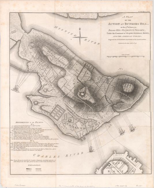
The Most Precise and Detailed Plan of the Battle of Bunker Hill

"A Plan of the Action at Bunkers Hill, on the 17th of June 1775. Between His Majesty's Troops, Under the Command of Major General Howe, and the American Forces: Engraved for Stedman's History of the American War", Stedman, Charles

Subject: Boston, Massachusetts

Period: 1793 (dated)

Publication: History of the Origin, Progress, and Termination of the American War

Color: Black & White

Size:
16.9 x 19.2 inches
42.9 x 48.8 cm
Download High Resolution Image
(or just click on image to launch the Zoom viewer)

This is the second state of the famous 1775 map by Lieutenant Thomas Hyde Page with the ground plan by Captain John Montresor. It illustrates the first major conflict of the two armies and is precisely detailed. The map was originally published by William Faden shortly after the battle and then appeared again in Stedman's History of the Origin, Progress, and Termination of the American War in 1793. Stedman's map is faithful to the original including the pasted down overlay map (9" x 6") titled "No. 1," which is often found missing. Charles Stedman was an American-born officer who served in the British Army during the American Revolution. Stedman served under Howe, Clinton and Cornwallis, and wrote a history on the war with explanations of the military campaigns and depictions of battle plans. Stedman's plan is nearly identical to Faden's, with the key exception of the title. Faden refers to the opposition as the Rebel Forces, whereas Stedman refers to them as the American Forces. In addition, Stedman omits the attribution to Lieut. Page and Capt. Montresor. Stedman also clarifies the location of the British and American troops by identifying the rectangular formations with different shading.

The map gives a vivid view of the warfare from the Charlestown Neck north of the Charlestown Peninsula to the northern tip of Boston. The plan depicts the locations and movements of the major players during the battle. Warren's redoubt and several lines of American forces are shown along Breed's Hill, adjacent to the city of Charlestown. The advancements of Brigadier General Pigot are depicted moving from the beach north towards Breed's Hill. British warships are shown at the mouth of the Charles River. There is scarce detail within the town of Boston with the exception of the Corps Hill Redoubt and Battery. The overlay gives the initial troop deployments, while the main map shows the final movements and positions of the British troops. At bottom left is a lettered key giving details of the troop movements for both the main map and the overlay.

References: Nebenzahl (Biblio) #29; cf. Nebenzahl & Higginbotham (Amer. Rev.) #4.

Condition: B+

A crisp impression issued folding on sturdy paper with light scattered foxing. Small remnants of hinge tape on verso.

Estimate: $1,200 - $1,500

Sold for: $900

Closed on 2/17/2016

Archived