Catalog Archive
Auction 155, Lot 126

"Carte de la Riviere de Richelieu et du Lac Champlain, Dressee sur les Manuscrits du Depost des Cartes, Plans, et Journx. de la Marine", Bellin, Jacques Nicolas

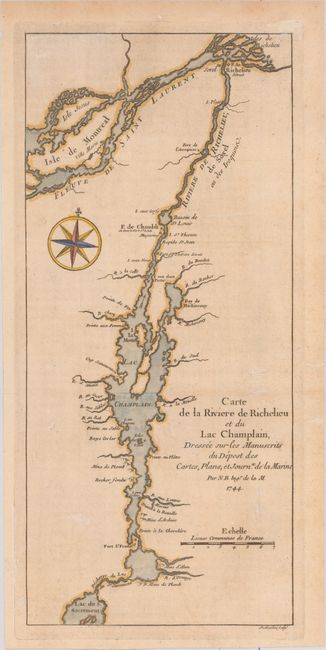
Subject: New York, Vermont, and Southern Quebec

Period: 1744 (dated)

Publication: Charlevoix's Histoire et Description Generale de la Nouvelle France

Color: Hand Color

Size:
5.4 x 11.9 inches
13.7 x 30.2 cm
Download High Resolution Image
(or just click on image to launch the Zoom viewer)

This unusual map covers the Richelieu River, Lake Champlain, and Lake George, with a portion of the St. Lawrence River. Lake George is called Lac du S. Sacrament, and it has an odd, round second lake above it. The English renamed the lake after King George II in 1755. This waterway was an important route between Montreal and the Hudson River, and it was important tactically during the French and Indian War. The map was drawn from manuscript sketches brought back to Paris by Pierre Francois Xavier de Charlevoix (1682-1761), a Jesuit Priest who explored Canada and the eastern and southern regions of North America between 1705-1720. Engraved by Guillaume Dheulland (1700-1770), a foremost engraver under the direction of Jacques Nicolas Bellin (1703-1772), the Royal Hydrographer to the King in Paris..

References: Tooley (MCC-96) #695.

Condition: B+

Issued folding on a watermarked and lightly toned sheet with some faint spots.

Estimate: $200 - $240

Sold for: $180

Closed on 11/18/2015

Archived