Catalog Archive
Auction 154, Lot 544

Rare Map of Russia Depicting An Overland Route from Moscow to Beijing

"Les Etats du Czar ou Empereur des Russes en Europe et en Asie, avec les Routes q'uon Tient Ordinairement de Moscow a Pekim...", Fer, Nicolas de
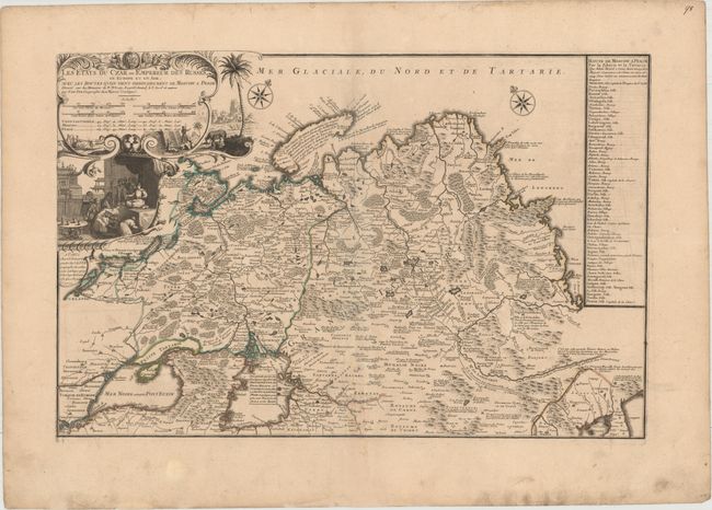
Subject: Russia

Period: 1722 (dated)

Publication: Atlas ou Recueil de Cartes Geographiques

Color: Hand Color

Size:
25.4 x 16.7 inches
64.5 x 42.4 cm
Download High Resolution Image
(or just click on image to launch the Zoom viewer)

This rare, large map of the Russian Empire extends from the Black Sea in the west to Korea in the east. The map is filled with details of towns, political boundaries, rivers, topography, and roads. There are numerous notations throughout, such as a note along the Great Wall of China that states that the famous wall was uselessly built to protect the Chinese from the advances of the Tartars. A table at right lists the various towns and sights along the road from Moscow to Peking (Beijing) based on Adam Brand's account of his trip to China with the Russian ambassador, Evert Ysbrandszoon Ides. The trip, which began in 1692, is illustrated on the map. De Fer also credits the cartography on the map to Nicolaas Witsen, who published an authoritative account on Russia, Noord en Oost Tartarye, and Philippe Avril, who published a work on the various overland routes used by Russians to travel from Moscow to China. The handsome title cartouche features a vignette of a Russian dignitary visiting the Chinese emperor.

References: Pastoureau, FER II C [90].

Condition: B

Original color on watermarked paper with wide margins and light soiling. There is an old tape stain along centerfold at bottom that has been removed and professionally repaired with a tiny amount of text in facsimile.

Estimate: $1,600 - $1,900

Sold for: $1,200

Closed on 9/16/2015

Archived