Catalog Archive
Auction 154, Lot 451

"Het Canaal Tusschen Engeland en Vrancriick", Goos, Pieter

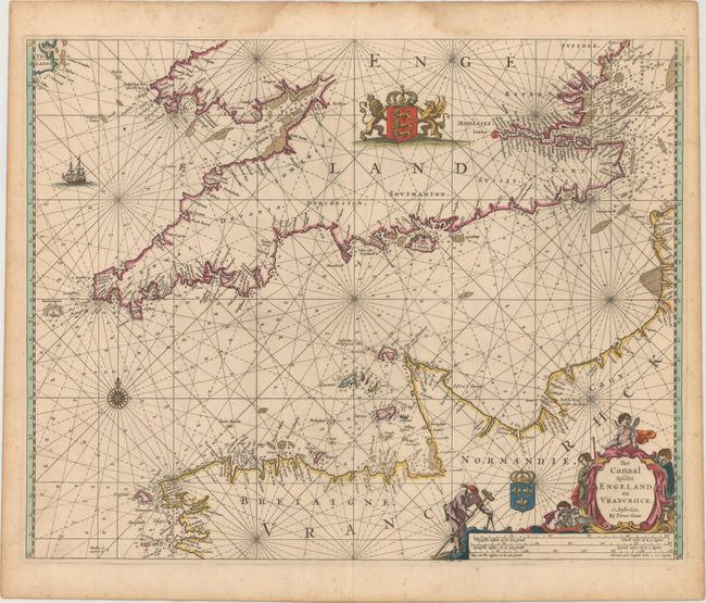
Subject: English Channel

Period: 1666 (circa)

Publication: De Zee-Atlas, Ofte Water-Woereld...

Color: Hand Color

Size:
21.5 x 17 inches
54.6 x 43.2 cm
Download High Resolution Image
(or just click on image to launch the Zoom viewer)

This elegantly engraved chart depicts the English Channel in terrific detail. Portions of England and France appear with largely blank interiors but plenty of place names along the coasts. Within the channel, criss-crossed by rhumb lines, there is a compass rose, a sailing ship, and several soundings and anchorages. The leonine Royal Arms of England appear in England, and the French coat of arms is shown within France. There is a decorative title and distance scale cartouche at bottom right.

Pieter Goos was one of Amsterdam's most successful publishers of nautical charts, with an impressive international clientele of shipowners, officials, and navigators. Only the publishing houses of Blaeu and Van Keulen shared a comparable esteem. His maritime atlas of the world was one of the most complete sea atlases published prior to the appearance of Van Keulen's Zeefakkel in the 1680’s.

References: Putnam, pp. 99-100.

Condition: A

A sharp impression in original color, backed with old paper as issued, with very minor soiling. There are damp stains in the top blank margin and toning along the edges of the sheet, well away from map image.

Estimate: $950 - $1,200

Sold for: $550

Closed on 9/16/2015

Archived