Catalog Archive
Auction 154, Lot 280

Extremely Rare Promotional Map with Railroad Overprint

"Lloyd's Official Map of the State of Virginia From Actual Surveys by Order of the Executive 1828 & 1859...", Lloyd, James T.
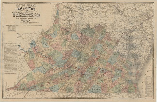
Subject: Virginia

Period: 1862 (dated)

Publication:

Color: Hand Color

Size:
47.3 x 30.4 inches
120.1 x 77.2 cm
Download High Resolution Image
(or just click on image to launch the Zoom viewer)

This scarce, large-scale folding map depicts Virginia during the Civil War, and was based on the Boye-Bucholtz four-sheet map of 1859. Originally published as a nine-sheet map in 1827, the Boye-Bucholtz map of Virginia was a landmark in its time, being "the largest and finest map of the state produced in the nineteenth century," according to Wooldridge. The surveying, drafting and engraving took a decade of work and $80,000 to complete and resulted in a map that was nearly forty square feet in size. A reduced-size version was also authorized, which appeared in 1859 and served as the basis for Lloyd's map of the state. Of course when Lloyd first published his edition in 1861, he marketed it as "Lloyd's $100,000 Topographical Map of Virginia Used by the War Department." And although the title of the map was "Lloyd's Official Map of the State of Virginia," the map had not been granted any official status by the state government.

Lloyd's map underwent several editions with varying text and advertisements surrounding the map, including an updated edition in 1862 based on surveys made by W. Angelo Powell of the U.S. Topographical Engineers. In 1872, red overprinting was added to the map to highlight the railroads throughout the state. This change not only enhanced the appearance and usefulness of the map, but also served as a marketing tool. Following the Civil War, Lloyd's map was used as part of a promotional effort to promote British immigration to Lynchburg to assist in the growing tobacco industry. Lynchburg, marked with a large star, is depicted as the center of the railroad infrastructure, with spokes radiating outward in all directions. A column of text at left further encourages settlement around Lynchburg, with descriptions of the Tidewater, Piedmont and Great Valley Districts of Virginia. The Piedmont District is described as having "superior and durable soil" and a "healthy and delightful" climate. In contrast, the Tidewater District is described as "sandy or gravelly" with "bilious and malarious fevers" prevailing during the summer and autumn, and the Great Valley is "deficient in running water" and "cold and damp" during the winter. Individuals wanting more information about Virginia are instructed to contact the Commissioner of Immigration in Lynchburg.

Five railroad lines are depicted: the Atlantic, Mississippi and Ohio; the Richmond and Lynchburg; the Lynchburg and Danville; the Orange, Alexander and Manassas; and the Chesapeake and Ohio. The red lettering denoting each railroad appears to have been stenciled. The railroads are also identified with bold, engraved black lines. The Lynchburg and Danville Railroad, which was built after the Civil War, is not marked by an engraved line, giving evidence to the fact that this map was not updated after the 1862 edition.

Previous editions of Lloyd's map were published by Lloyd himself, however this edition was published by Wynkoop & Hallenbeck in New York, whose imprint appears below the title. The 1862 edition included a note below the title stating that: "This is the only map used to plan campaigns in Virginia by General McClellan." This edition omits the reference to the Civil War, likely because the war was over and McClellan had been disgraced.

References: Wooldridge, pp. 257-61; cf. Stephenson #465.

Condition: A

Full original color with minor toning and a few small spots in the title. Issued folding, now pressed and professionally backed in linen to repair several short fold separations and provide support. There are a few tiny areas of loss, as well as a 3/4" area of loss in Maryland just south of DC, that have been replaced in skillful facsimile. This well preserved example has been expertly conserved. There is minor discoloration in the image (appearing as bluish shadows) that is caused by our scanner, and does not appear on the map itself.

Estimate: $3,000 - $4,000

Unsold

Closed on 9/16/2015

Archived