Catalog Archive
Auction 154, Lot 272

NO RESERVE

"(Sketch 1 No 4) Preliminary Chart of San Luis Pass Texas…", U.S. Coast Survey

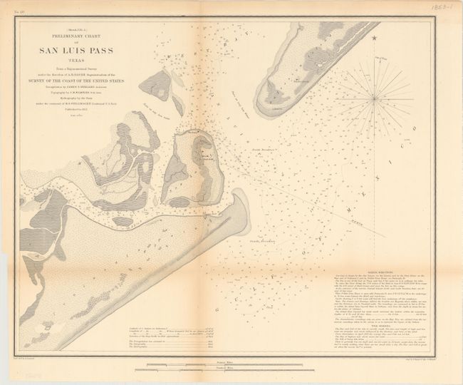
Subject: Galveston Bay, Texas

Period: 1853 (dated)

Publication:

Color: Black & White

Size:
17 x 14 inches
43.2 x 35.6 cm
Download High Resolution Image
(or just click on image to launch the Zoom viewer)

The Office of Coast Survey is the oldest U.S. scientific organization, dating from 1807 when Congress directed that a "survey of the coast" be carried out. By 1836, it was called the U.S. Coast Survey and in 1878, the name was changed to the U.S. Coast and Geodetic Survey. Today the Office of Coast Survey is a division of the National Oceanic and Atmospheric Administration NOAA.

The survey teams, composed of civilians as well as Army and Naval officers, charted the nation's waterways and produced a wide array of reports, survey charts, hydrographic studies of tides and currents, astronomical studies and observations, and coastal pilots. These charts are an important record of the changing nature of the nation's coastlines. In additional to coastal charts, the U.S. Coast and Geodetic Survey produced land sketches, Civil War battle maps, and the early aeronautical charts.

Handsome chart of the entrance to Galveston Bay, noting San Luis Island, Galveston and Mud Island as well as Peninsula Point. The chart notes soundings, sailing directions and tidal effects.

References:

Condition: B+

Issued folding with a binding trim at lower left and some light toning along the folds.

Estimate: $130 - $160

Sold for: $1

Closed on 9/16/2015

Archived