Catalog Archive
Auction 154, Lot 269

NO RESERVE

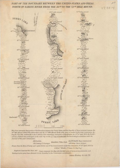
"Part of the Boundary Between the United States and Texas; North of Sabine River from the 36th to the 72nd Mile Mound", U.S. Government

Subject: Texas, Louisiana

Period: 1842 (circa)

Publication: Sen. Doc. No. 199, 27th Cong., 2d Sess.

Color: Black & White

Size:
6.3 x 10.8 inches
16 x 27.4 cm
Download High Resolution Image
(or just click on image to launch the Zoom viewer)

This small map came out of the highly desirable report on the boundary survey between the Republic of Texas and the United States. Streeter calls this publication of "prime importance" and the maps "the most important in Texas history, in that they show the final boundary between Texas and the U.S. from the Gulf of Mexico to the Red River."

The map itself, in strip-style format, covers the area from approximately Shelburne, through Ferry Lake, to just north of Black Bayou. It is drawn on a detailed scale of about 0.7" per mile. Below the map are the signatures of J.H. Overton and J.R. Conway from the United States Surveyor’s Office, and George Smyth and A.B. Gray on the Texas side. Authenticated by Lt. Col. James Kearney. Engraved by W.J. Stone.

References: Streeter #1442.

Condition: B

Issued folding with light soiling and a few extraneous creases.

Estimate: $200 - $250

Sold for: $10

Closed on 9/16/2015

Archived