Catalog Archive
Auction 154, Lot 260

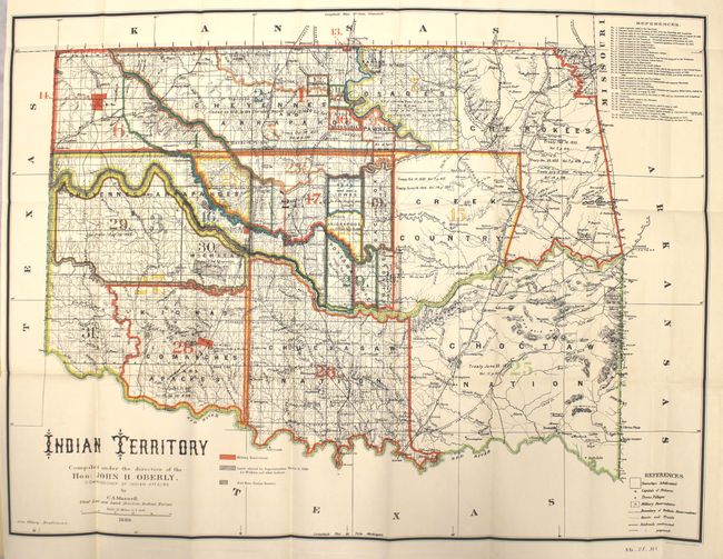
"[Map in Report] Indian Territory Compiled under the Direction of Hon: John H. Oberly, Commissioner of Indian Affairs", U.S. Bureau of Indian Affairs

Subject: Oklahoma

Period: 1889 (dated)

Publication: Sen. Ex. Doc. 78, 51st Cong., 1st Sess.

Color: Printed Color

Size:
31.8 x 23.6 inches
80.8 x 59.9 cm
Download High Resolution Image
(or just click on image to launch the Zoom viewer)

This colorful, detailed and informative map of present-day Oklahoma is sans its panhandle. Legends identify military reservations, Indian reservations, roads, trails, and railroads. Watershed and topography are well developed. Thirty-one different Indian lands are noted with information on pertinent treaties and Executive Orders, all keyed to the map. Attractive and large sheet lithographed by A. Hoen & Co, Baltimore. Still bound into the original 31 pp. report.

References:

Condition: A+

Condition code is for the map which is clean, bright and flawless. Text is near fine with light toning.

Estimate: $500 - $650

Sold for: $400

Closed on 9/16/2015

Archived