Catalog Archive
Auction 154, Lot 168

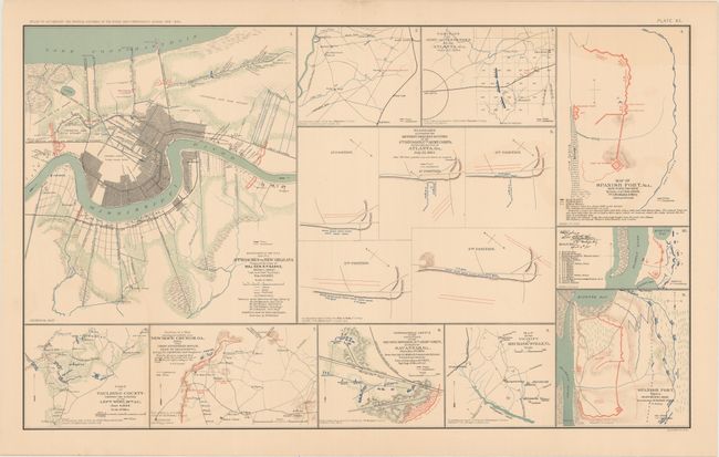
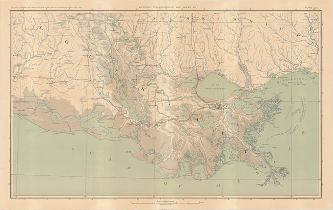
"[Lot of 2] Map No. 5. Approaches to New Orleans, Prepared by Order of Maj. Gen. N.P. Banks... [and] General Topographical Map. Sheet XXI", U.S. War Department

Subject: Southern United States, Civil War

Period: 1891-95 (published)

Publication: Atlas to Accompany the Official Records of the Union and Confederate Armies...

Color: Printed Color

Size:
27.5 x 16.6 inches
69.9 x 42.2 cm
Download High Resolution Image
(or just click on image to launch the Zoom viewer)

This lot of Civil War sheets comes from the government's comprehensive atlas covering the War Between the States. These plates were issued between 1891 and 1895 to accompany the Official Army Records and were published under the Secretaries of War Redfield Proctor, Stephen B. Elkins, and Daniel S. Lamont by Maj. Gen. George B. Davis, assisted by civilian experts Leslie Perry and Joseph Kirkley. The first features 11 small maps and diagrams, including a map depicting the approaches to New Orleans, with the city shown in plan form, and several diagrams detailing the positions of the armies involved in the Battle of Atlanta. Other maps focus on critical areas in Georgia, Alabama, and Virginia. The second sheet is a map covering the alluvial region of Louisiana and the Mississippi Gulf Coast. The area's intricate network of waterways is rendered in fine detail, and several towns and cities are named, including New Orleans and Baton Rouge. Size varies slightly.

A. Map No. 5. Approaches to New Orleans, Prepared by Order of Maj. Gen. N.P. Banks... . Condition: There is faint color offsetting and short centerfold separations in the top and bottom blank margins. (A)
B. General Topographical Map. Sheet XXI. Condition: Light toning and a few faint damp stains with a short archivally repaired centerfold separation in the bottom blank margin. (B+)

References:

Condition:

See description above.

Estimate: $180 - $210

Sold for: $95

Closed on 9/16/2015

Archived