Catalog Archive
Auction 154, Lot 155

A Seminal Map of the Southeast and Early American Cartography

"Virginiae Item et Floridae Americae Provinciarum, Nova Descriptio", Hondius, Jodocus

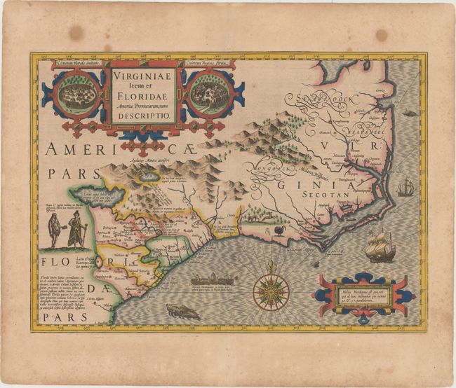
Subject: Colonial Southeast United States

Period: 1628 (published)

Publication: Gerardi Mercatoris - Atlas sive Cosmographicae

Color: Hand Color

Size:
19.3 x 13.6 inches
49 x 34.5 cm
Download High Resolution Image
(or just click on image to launch the Zoom viewer)

This stunning map was compiled from two of the most important source maps of the early colonial period: John White's Virginia and Jacques le Moyne's Florida. Hondius' map became the prototype map of the region for the first half of the 17th century and continued to influence the cartography of the region until the middle of the 18th century. Largely due to the enormous success of Hondius' Atlas, Le Moyne's erroneous depiction of a large inland lake (Lacus aquae dulcis) from which the R. de May (St. John's River) flows in a southeasterly direction was popularized. Chesapeake Bay, here called Chesepioock Sinus, and the area south towards C.S. Romano Hispanis are shown in their White delineations. The Indian villages of Paquiwok, Croatoan, and Wococon are named in the Outer Banks and several others along the Albemarle and Pamlico Sounds. The map is extensively decorated with depictions of Indian villages incorporated in the title cartouche, a Floridian king and queen and Virginian natives in a canoe taken from De Bry, wildlife including a wild turkey, ships, sea monsters and a superb compass rose. French text on verso.

References: Burden #151; Cumming (SE) #26; Williams & Johnson #3; Van der Krogt (Vol. I) #9400:1A.

Condition: B+

A nice impression with bold color, wide margins, light toning, and scattered foxing primarily confined to the blank margins. There are several stains in the top blank margin.

Estimate: $2,200 - $3,000

Unsold

Closed on 9/16/2015

Archived