Catalog Archive
Auction 154, Lot 132

"[A Map of the Most Inhabited Part of New England - Northeast Quadrant]", Lotter, Tobias Conrad

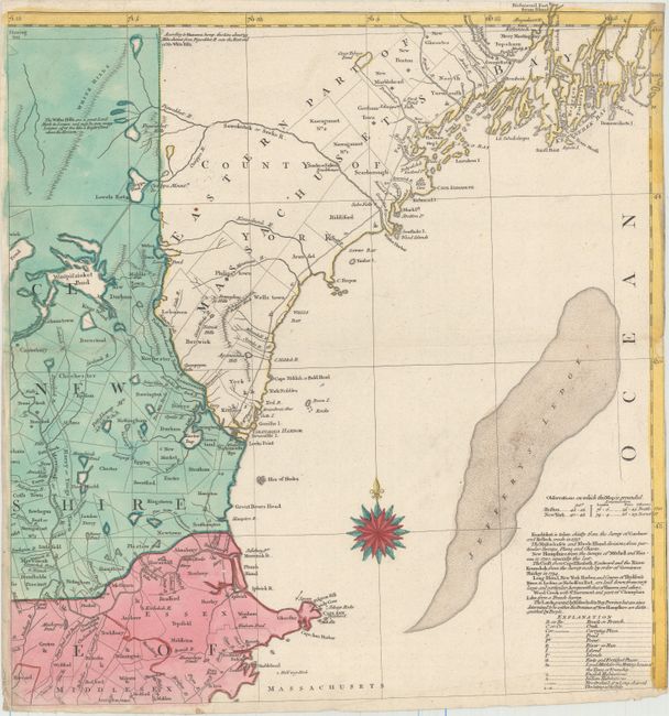
Subject: Colonial New England

Period: 1776 (published)

Publication:

Color: Hand Color

Size:
19.3 x 20.1 inches
49 x 51.1 cm
Download High Resolution Image
(or just click on image to launch the Zoom viewer)

This is the northeast sheet of Lotter's German edition of one of the most detailed, accurate, and certainly most visually impressive, maps of New England. The four-sheet map was originally published by Thomas Jefferys in 1755 (McCorkle #755-19), at the beginning of the French and Indian War. Jefferys' map was compiled by Braddock Mead (alias John Green) from influential contemporary sources, but curiously not including Douglass’ Plan of the British Dominions of New England in North America. Lotter's edition does not give attribution to Jefferys’ map, but is virtually identical. Lotter maintains English nomenclature throughout, likely to assure the German audience of the authenticity of the source of information. This pre-Revolutionary War map provides remarkable detail in the region including villages, towns, roads, counties, watershed, mountains and topography, information along the coast, and much more. This northeast sheet extends from Cape Ann, Massachusetts in the south to Fort Richmond, Maine in the north, and as far west as Lake Winnipesaukee and Merrimack River in New Hamshire. At bottom right is a note of various surveys and land grants in the region, along with the legend for the map.

References: McCorkle 776.16; Sellers & Van Ee #801; cf. Pritchard & Taliaferro #35.

Condition: B

A clean and bright example with original color on watermarked paper. There is one small hole in northeastern Massachusetts, some light extraneous creasing, and an archivally repaired tear that extends 5" into image at left. Trimmed at right with some loss of neatline.

Estimate: $800 - $950

Sold for: $400

Closed on 9/16/2015

Archived