Catalog Archive
Auction 153, Lot 673

"Speed" Map of Southeast Asia

"A New Map of East India", Speed/Lamb

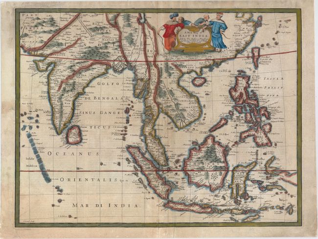
Subject: Southeast Asia

Period: 1676 (circa)

Publication: A Prospect of the Most Famous Parts of the World

Color: Hand Color

Size:
19.9 x 15.1 inches
50.5 x 38.4 cm
Download High Resolution Image
(or just click on image to launch the Zoom viewer)

This handsome map of Southeast Asia, based on Frederick de Wit's map of 1662, was engraved by Francis Lamb for the last edition of John Speed's popular world atlas. The map covers from southeastern Persia to Formosa (Taiwan), the Philippines, and Indonesia. The map illustrates the region in which the Dutch East India Company (VOC) had built a great trading empire in the seventeenth century; a region over which the English sought to gain control. Much of the information is very generalized due to Dutch secrecy about the region. The great rivers of Southeast Asia are not shown, and all except the Mekong are shown as having their source in the mythical Lake Chiamay in China. A prominent feature in northern India is the royal road of the Moguls between Agra to Lahore, shown as a broad tree-lined route. The verso contains a description of India in English text. Published by Bassett and Chiswell.

References: Parry (SEA) plt. 5.3, pp135-36; Moreland & Bannister, p.273; Shirley (BL Atlases) T.SPE-2f #27.

Condition: B+

A crisp impression on watermarked paper with light soiling and a professionally repaired centerfold separation that enters 3" into map at bottom. There are additional professional repairs to several small chips and tears in the blank margin, including one tear that enters the map border at top left.

Estimate: $1,600 - $1,900

Sold for: $1,200

Closed on 5/20/2015

Archived