Catalog Archive
Auction 153, Lot 611

Adrichom's Influential Map of the Holy Land

"Situs Terrae Promissionis SS Bibliorum Intelligentiam Exacte Aperiens", Adrichom, Christian van
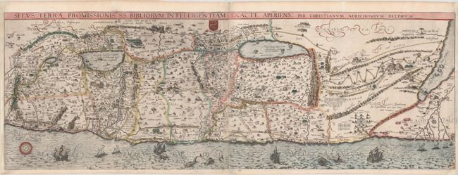
Subject: Holy Land

Period: 1613 (circa)

Publication: Theatrum Terrae Sanctae

Color: Hand Color

Size:
39.7 x 14 inches
100.8 x 35.6 cm
Download High Resolution Image
(or just click on image to launch the Zoom viewer)

Adrichom's stunning map of the Holy Land was based on numerous sources, including Peter Laicksteen and Christian Sgrooten, Tilleman Stella, Jacob Ziegler, Sebastian Munster, Gerard Mercator, Buchard of Mt. Sion, and even Josephus, Jerome and Ptolemy. This map became immediately popular with leading cartographers such as Jan Jansson and Nicholas Visscher, who used it as the basis for their own maps of the Holy Land. With north oriented to the bottom left, the map extends from the Nile delta to Sidon and is divided into the twelve tribes. There is no bend where Palestine meets Egypt, and the Kishon River erroneously connects the Sea of Galilee with the Mediterranean. The map is finely engraved with minute detail and depicts numerous biblical scenes including the Exodus, Jonah and the Whale, the wandering of the Children of Israel, and several battle scenes. Four burning cities are shown in the Dead Sea: Sodoma, Gomorra, Seboim, and Adama. Sailing ships, sea monsters, Adrichom's coat of arms, and a compass rose complete the composition. On two sheets, joined as issued.

The Theatrum Terrae Sanctae was an atlas and history of the Holy Land and was Adrichom's most important and famous work. Born in Delft, Christian Kruik van Adrichem, or Christianus Crucius Adrichomius, was a Catholic priest and theologian. Adrichom worked for thirty years on his three-part history of the Holy Land, and only succeeded in publishing the first part, Urbis Hierosolyma Depicta, during his lifetime. The remaining two parts were published posthumously by Georg Braun in 1590, with subsequent editions in 1593, 1600, 1613, 1628, and 1682. The Theatrum Terrae Sanctae contained 12 maps and plans: one of the Holy Land, nine of territories of the Tribes of Israel, one of the Exodus, and a town plan of Jerusalem.

References: Nebenzahl (Holy Land) pp. 94-97; Laor #7.

Condition: B+

Issued folding on watermarked paper with attractive color, some abrasions along the joint, and minor soiling. There are professional repairs to several tiny tears (one at center of image and the remainder along the edges of the sheet) and two small chips at bottom corners, with a minor amount of image replaced in facsimile. The right and left margins have been extended to accommodate framing.

Estimate: $1,500 - $1,800

Unsold

Closed on 5/20/2015

Archived