Catalog Archive
Auction 153, Lot 4

Ortelius' Third World Map in an Oval Projection

"Typus Orbis Terrarum", Ortelius, Abraham
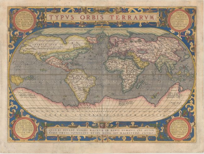
Subject: World

Period: 1587 (dated)

Publication: Theatrum Orbis Terrarum

Color: Hand Color

Size:
19.3 x 13.9 inches
49 x 35.3 cm
Download High Resolution Image
(or just click on image to launch the Zoom viewer)

Ortelius' beautiful oval world map is a simplified version of Mercator's influential map of 1569. From surviving correspondence, it is known that Mercator encouraged Ortelius and provided him with information, particularly with co-ordinates of places in the Americas. This is the first state of Ortelius' third world map updated with the more correct shape of South America and the first depiction of the Solomon Islands off the coast of New Guinea. North America is nearly bisected by a lengthy St. Lawrence River, and the lands of Anian Regnum and Quivira are noted on the western coast. The Atlantic Ocean is filled with phantom islands, including Frieslant, St. Brandain, Brasil and many others. A huge Southern Continent incorporates Tierra del Fuego, and the mythical lands of Beach, Maletur and Lucach. The oval projection is surrounded by an intricate strapwork design with four corner medallions containing quotations from Cicero and Seneca. French text on verso, published in 1598.

References: Shirley #158; Van den Broecke #3.1.

Condition: B

A fine impression with attractive color and light soiling. The map has been backed in Japanese tissue with professional repairs two diagonal tears that extend 4" through title cartouche and 5" through quote at bottom, as well as several other shorter tears. Some small chips and tears in blank margins have also been professionally repaired.

Estimate: $5,500 - $7,000

Sold for: $3,750

Closed on 5/20/2015

Archived