Catalog Archive
Auction 153, Lot 468

"Heather's New Chart of the Coasts of England and Holland from the Latest Surveys", Heather, William
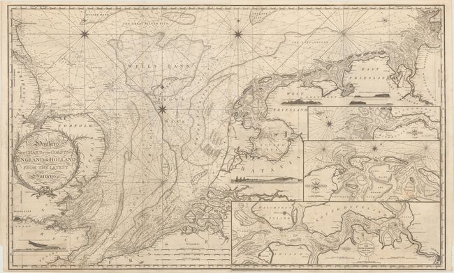
Subject: North Sea

Period: 1805 (dated)

Publication:

Color: Black & White

Size:
49.8 x 30.7 inches
126.5 x 78 cm
Download High Resolution Image
(or just click on image to launch the Zoom viewer)

This is an incredible, large-scale chart of the North Sea covering the English coast from Dover to Flamborough Head, and on mainland Europe from Calais to Bremen. There is an abundance of information on soundings, anchorages, banks, shoals, currents, and coastal place names. The interior of the map includes insets of the River Scheldt, River Elbe and the Texel and Vlie Islands and 5 coastal views including Dover and Calais. Engraved by J. Stephenson. Printed on two sheets, joined.

At the end of the 18th century Britain played a leading role in chart making and William Heather was among the most prominent cartographers of the period. He succeeded Mount and Page in 1765 and then established a Naval Academy and the Naval Warehouse, which provided nautical instruments, charts and instructional texts on navigation. Heather later changed the name of his publishing company to "Heather & Williams." This name remained until John William Norie, who began his career working for Heather, took over the company after Heather's retirement and renamed it the J.W. Norie and Company in 1813.

References: Phillips (Atlases) #2850 [7].

Condition: B+

A fine impression with minor soiling, a few spots of foxing, and a 1" tear to the left of Black Bank that has been archivally repaired.

Estimate: $1,500 - $1,800

Sold for: $1,000

Closed on 5/20/2015

Archived