Catalog Archive
Auction 153, Lot 2

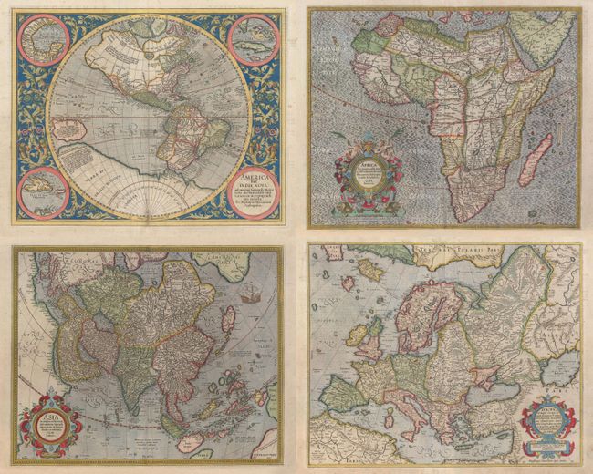
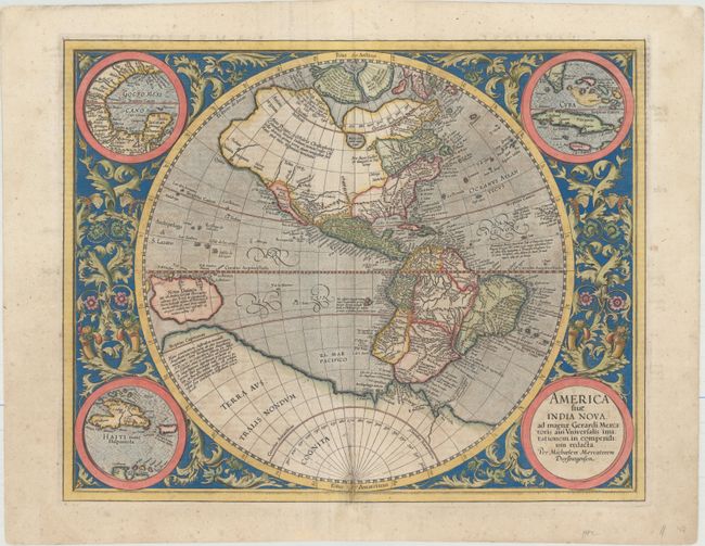
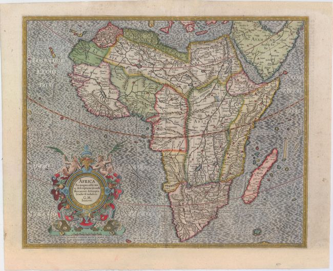
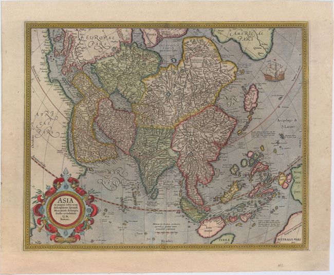
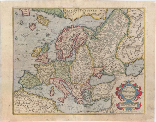
Matching Set of Continents by Mercator

"[Lot of 4] America sive India Nova, ad Magnae Gerardi Mercatoris… [and] Africa ex Magna Orbis Terre Descriptione Gerardi Mercatoris [and] Asia ex Magna Orbis Terre Descriptione Gerardi Mercatoris [and] Europa, ad Magnae Europae Gerardi Mercatoris", Mercator/Hondius

Subject: Continents

Period: 1628 (circa)

Publication: Gerardi Mercatoris - Atlas sive Cosmographicae

Color: Hand Color

Size:
See Description
Download High Resolution Image
(or just click on image to launch the Zoom viewer)

This is a handsome matching set of continents from a French edition of Mercator's Atlas, published in both 1628 and 1633. This set includes:

A. America sive India Nova, ad Magnae Gerardi Mercatoris aui Universalis Imitationem in Compendium Redacta (18.3 x 14.6"). This is one of the most famous maps of the Americas and an important foundation map for an American map collection. After the death of his grandfather, Michael Mercator produced this stunning hemispherical map, the only known printed map attributed to him. The map is surrounded by a beautifully engraved floral design and four roundels, one of which contains the title. The other insets include the Gulf of Mexico, Cuba, and Haiti. The geography was patterned after Rumold Mercator's world map of 1587, with a little added detail. There is a large inland lake in Canada, and the St Lawrence River extends nearly halfway across the continent with no Great Lakes. There is a still a bulge in the west coast of South America. The large southern continent extends above the Tropic of Capricorn in the Pacific where there is a very large island of New Guinea. Above North America are two of the four islands of the North Pole, with the great mythical rivers flowing from the pole. The seas are full of mythical islands, including St. Brendain, Frislant and Sept citez. References: Burden #87; Van der Krogt (Vol. I) #9000:1A. Condition: Minor toning and a professionally repaired tear adjacent to centerfold that enters 3" into map at bottom. A 1" tear west of Chile has also been archivally repaired.

B. Africa ex Magna Orbis Terre Descriptione Gerardi Mercatoris Desumpta, Studio & Industria G.M. Iunioris (18.5 x 15.0"). Compiled from Gerard Mercator's world map of 1569, this rendition was drawn by Mercator's grandson (also named Gerard) in 1595, and published later by Hondius. The map is typical of 16th century cartography with considerable fantastic detail in the interior. The depiction of the Nile is based on Ptolemy's geography with some complex modifications from various sources, including Abyssinian monks. The source of the Nile is shown as a series of lakes located in the Lune montes just north of the Tropic of Capricorn. Another branch of the Nile flows from the west, with this system rambling through what is the Sahara Desert. Mercator adds a lake named Sac. Haf lac, from the 1507 Waldseemuller world map. This lake feeds both the Zambere River and the Nile. In Abissini, the legendary Christian King Prester John sits on his throne. The boldly engraved oceans, beautiful calligraphy, and strapwork cartouche (surmounted by two satyrs) make this a decorative masterpiece. References: Betz #31; Norwich #21; Van der Krogt (Vol. I) #8600:1A. Condition: There are professional repairs to a centerfold separation at bottom and several small adjacent tears, with minor loss of image. A few creases have been pressed flat and professionally reinforced on verso. The bottom margin has been extended to accommodate framing.

C. Asia ex Magna Orbis Terre Descriptione Gerardi Mercatoris Desumpta, Studio et Industria G.M. Iunioris (18.4 x 14.8"). Derived from the elder Mercator’s world map of 1569, this map of Asia was also engraved by his grandson. The coasts of Northeast Asia and Northwest North America are separated by Gastaldi's fabled Strait of Anian. South of this strait a beautifully engraved galleon gives speculation to the possibility of a northern route to Asia. Sumatra has a curiously archaic outline, while the relationship between New Guinea and Terra Australis is left to the viewer's imagination. The place names, Beach, Regio, Lucach and Maletur are all taken from Marco Polo's account, but erroneously ascribed to locations in the vicinity of present-day Australia. References: Yeo #13; Parry #3.13, Van der Krogt (Vol. I) #8000:1A. Condition: There are a couple of minor printer's creases and professional repairs to several separations along the centerfold and to a short adjacent tear at bottom. The top and bottom margins have been extended to accommodate framing.

D. Europa, ad Magnae Europae Gerardi Mercatoris P. Imitationem, Rumoldi Mercatoris Cura Edita... (18.6 x 15.1"). A beautiful map in Mercator's strong engraving style with the seas filled with waves and the land dotted with tiny cities. All of Europe is depicted, as well as Americae Pars, Greenland, Iceland, a Polar landmass, along with the mythical islands of Frisland, Drogeo, and Bradain. A large strapwork title cartouche completes the sheet. References: Van der Krogt (Vol. I) #1000:1A. Condition: A small rust spot in Germany, and professional repairs to centerfold separations that just pass the neatline at top and enter 1.5" into map at bottom. There are additional professional repairs to a few small tears and chips in bottom blank margin, not affecting map.

References:

Condition: B+

Excellent impressions with attractive color. See above for additional details.

Estimate: $9,000 - $11,000

Sold for: $6,500

Closed on 5/20/2015

Archived