Catalog Archive
Auction 153, Lot 24

"A View of ye General & Coasting Trade-Winds, Monsoons or ye Shifting Trade Winds Through ye World, Variations &c. According to the Newest and Most Exact Observations", Moll, Herman
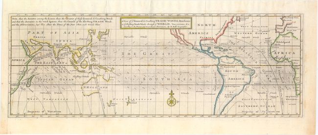
Subject: World

Period: 1745 (circa)

Publication: Modern History

Color: Hand Color

Size:
20.6 x 7.2 inches
52.3 x 18.3 cm
Download High Resolution Image
(or just click on image to launch the Zoom viewer)

This chart describes the world between about 50° north and south latitude. This includes southern Newfoundland to just north of Tierra del Fuego. The chart shows nearly blank continents with just country names and little else. Its main focus is an extremely detailed view of sea-borne winds. The legend explains the lines and arrows used to delineate the "General & Coasting Winds" and the "Shifting Trade Winds." The arrows suggest the prevailing direction, but some are annotated with month or season to indicate a periodic wind rather than a year-round, reliable trade wind. Largely based on the work of the English scientist Sir Edmund Halley. Published in London in Thomas Salmon's Modern History: or the Present State of All Nations.

References: Shirley (BL Atlases) G.SALM-1c #39.

Condition: B+

Issued folding with a few spots of foxing in the image and remnants of hinge tape on verso.

Estimate: $350 - $425

Sold for: $375

Closed on 5/20/2015

Archived