Catalog Archive
Auction 153, Lot 239

NO RESERVE

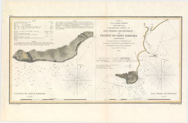
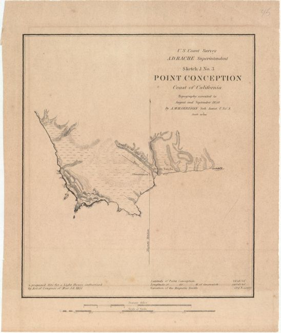
"[Lot of 2] (J No. 4) Preliminary Survey of San Pedro Anchorage and Vicinity of Santa Barbara California [and] Sketch J No. 3 Point Conception Coast of California", U.S. Coast Survey

Subject: Santa Barbara, California

Period: 1851-55 (dated)

Publication:

Color:

Size:
See Description
Download High Resolution Image
(or just click on image to launch the Zoom viewer)

The Office of Coast Survey is the oldest U.S. scientific organization, dating from 1807 when Congress directed that a "survey of the coast" be carried out. By 1836, it was called the U.S. Coast Survey and in 1878, the name was changed to the U.S. Coast and Geodetic Survey. Today the Office of Coast Survey is a division of the National Oceanic and Atmospheric Administration NOAA.

The survey teams, composed of civilians as well as Army and Naval officers, charted the nation's waterways and produced a wide array of reports, survey charts, hydrographic studies of tides and currents, astronomical studies and observations, and coastal pilots. These charts are an important record of the changing nature of the nation's coastlines. In additional to coastal charts, the U.S. Coast and Geodetic Survey produced land sketches, Civil War battle maps, and the early aeronautical charts.

A. (J No. 4) Preliminary Survey of San Pedro Anchorage and Vicinity of Santa Barbara California, dated 1855, hand color (14.3 x 7.3"). This interesting chart shows both Santa Barbara and San Pedro. Two magnetic roses, soundings, bottom types, and kelp appear in the water. There are notes on the tides at left. Engraved by J.J. Knight. Condition: There is a small faint small damp stain near the fold at bottom and a tiny tear on the neatline at left that has been closed with archival materials. The left margin has been extended to accommodate framing. Professionally backed in Japanese tissue. (A)

B. Sketch J No. 3 Point Conception Coast of California, dated 1851, black & white (6.8 x 7.6"). This small, elegant map shows Point Conception, California is fine topographical detail. Located where the Santa Barbara Channel meets the Pacific Ocean, the headland is the natural division between Central and Southern California. The proposed site for the Point Conception Lighthouse is shown; it was finally constructed in 1856 and is one of the state's oldest lighthouses. Condition: A nice impression with light offsetting from an opposing page and faint scattered foxing. (B+)

References:

Condition:

See description above.

Estimate: $150 - $180

Unsold

Closed on 5/20/2015

Archived