Catalog Archive
Auction 153, Lot 190

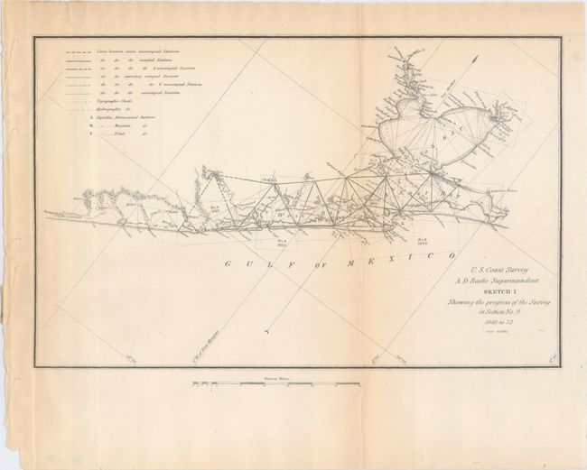
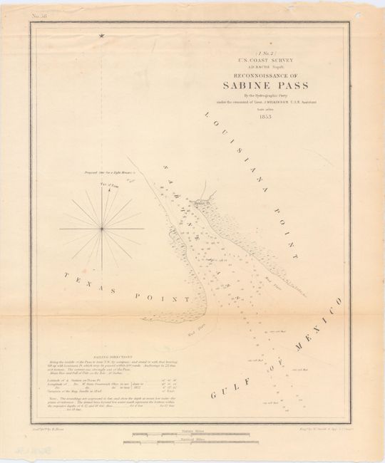
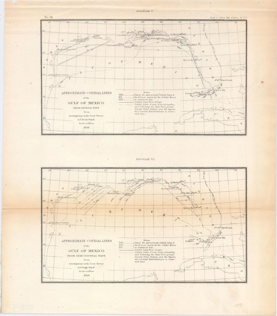
"[Lot of 3] Sketch I Showing the Progress of the Survey in Section No. 9 1848 to 52 [and] Reconnoissance of Sabine Pass [and] Approximate Cotidal Lines of the Gulf of Mexico from Diurnal Wave [on sheet with] Approximate Cotidal Lines ... Semi-Diurnal Wave", U.S. Coast Survey

Subject: Southern United States, Gulf of Mexico

Period: 1853-56 (circa)

Publication:

Color: Black & White

Size:
See Description
Download High Resolution Image
(or just click on image to launch the Zoom viewer)

The Office of Coast Survey is the oldest U.S. scientific organization, dating from 1807 when Congress directed that a "survey of the coast" be carried out. By 1836, it was called the U.S. Coast Survey and in 1878, the name was changed to the U.S. Coast and Geodetic Survey. Today the Office of Coast Survey is a division of the National Oceanic and Atmospheric Administration NOAA.

The survey teams, composed of civilians as well as Army and Naval officers, charted the nation's waterways and produced a wide array of reports, survey charts, hydrographic studies of tides and currents, astronomical studies and observations, and coastal pilots. These charts are an important record of the changing nature of the nation's coastlines. In additional to coastal charts, the U.S. Coast and Geodetic Survey produced land sketches, Civil War battle maps, and the early aeronautical charts.

A. Sketch I Showing the Progress of the Survey in Section No. 9 1848 to 52, circa 1853 (11.8 x 7.5"). Small but very important chart that shows early triangulations in and around Galveston Bay that were the basis for all later surveying in Texas.

B. Reconnoissance of Sabine Pass, dated 1853 (8.7 x 10.9"). This small chart depicts Sabine Pass, the boundary between the states of Texas and Louisiana. It is filled with numerous soundings, descriptions of the water's bottom, and sailing directions.

C. Approximate Cotidal Lines of the Gulf of Mexico from Diurnal Wave [on sheet with] Approximate Cotidal Lines of the Gulf of Mexico from Semi-Diurnal Wave, dated 1856 (8.2 x 10.6"). This sheet contains two charts showing the tidal cycles in the Gulf of Mexico. The top chart shows diurnal waves (those areas experiencing one high and one low tide every day), while the bottom chart shows semi-diurnal waves (two high tides and two low tides).

References:

Condition: B

Toning along the fold lines as is typical with most coast survey maps.

Estimate: $100 - $130

Sold for: $50

Closed on 5/20/2015

Archived