Catalog Archive
Auction 153, Lot 172

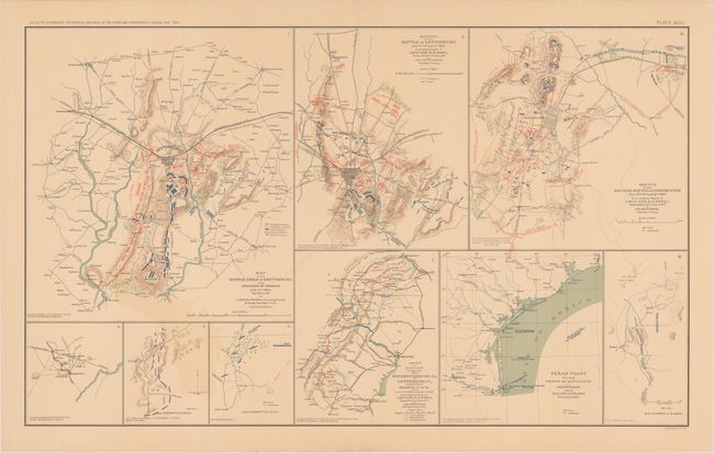
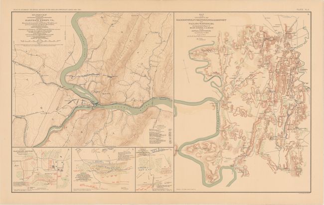
"[Lot of 2] Map of the Battle-Field of Gettysburg... [on sheet with] Sketch of the Battle of Gettysburg... [and] Military Map Showing ... the Country Adjacent to Harper's Ferry... [on sheet with] Map of the Vicinity of Hagerstown…", U.S. War Department

Subject: Mid-Atlantic United States, Civil War

Period: 1891-95 (published)

Publication: Atlas to Accompany the Official Records of the Union and Confederate Armies...

Color: Printed Color

Size:
27.3 x 16.4 inches
69.3 x 41.7 cm
Download High Resolution Image
(or just click on image to launch the Zoom viewer)

A. Map of the Battle-Field of Gettysburg... [on sheet with] Sketch of the Battle of Gettysburg... [and] Sketch of the Second Battle of Winchester... [and] Sketch of Routes 2nd Corps A.N.V. from Fredericksburg, VA. To Gettysburg, PA... [and] Texas Coast.... This sheet contains several intricately detailed maps of Civil War battlefields, with the majority of the maps focused on the battle of Gettysburg, widely considered to be the turning point of the war. The most prominent of the maps here shows the position of the troops on July 2nd, 1863, the final day of the battle. Next to this map is a smaller map describing all three days of the battle. The Second Battle of Winchester, part of the wider Gettysburg campaign, and a map detailing the routes taken by General Ewell's Second Corps, Army of Northern Virginia to and from Gettysburg are also featured. A series of smaller maps cover the configuration of Union troops during the Battle of Dallas in Georgia. Another map traces General Nathaniel P. Banks' campaign along the Gulf Coast in Texas, with notes on the steamers involved. In addition to depicting troop positions, each map includes fine topographical detail. Lithographed by Julius Bien & Co.

B. Military Map Showing the Topographical Features of the Country Adjacent to Harper's Ferry, VA. Including Maryland, Loudoun and Bolivar Heights... [on sheet with] Map of the Vicinity of Hagerstown, Funkstown, Williamsport and Falling Waters, MD... [and] Battle of Slaughter's Mountain... [and] Sketch at That Part of Field at Cold Harbor... [and] Sketch of the Battle-Field of Cross Keys, VA.... The topographical maps on this sheet are concentrated around the Potomac River. At top left is a map of Harpers Ferry as surveyed by Major John E. Weyss a few years after John Brown's legendary raid and just a year after the Battle of Harpers Ferry. It includes a table of distances at bottom right. A larger map appears next to this one, centered on the towns of Hagerstown, Funkstown, and Williamsport in western Maryland. This region was of particular importance during the Civil War because of its strategic location on the border between the North and the South. Three smaller maps at bottom left depict three Virginia battlefields in the summer of 1862: Cedar Mountain (here Slaughter's Mountain), Cold Harbor, and Cross Keys. Lithographed by Julius Bien & Co.

References:

Condition: B+

Both maps have light toning, minor offsetting, and a few short edge tears confined to the blank margins.

Estimate: $150 - $180

Sold for: $110

Closed on 5/20/2015

Archived