Catalog Archive
Auction 152, Lot 506

"Carte Generale des Etats du Czar Empereur de Moscovie...", Chatelain, Henry Abraham
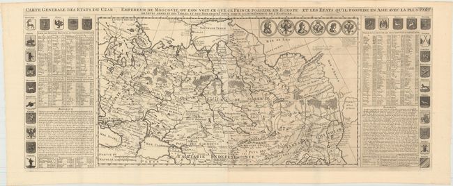
Subject: Russia

Period: 1719 (circa)

Publication: Atlas Historique

Color: Black & White

Size:
38.3 x 15.3 inches
97.3 x 38.9 cm
Download High Resolution Image
(or just click on image to launch the Zoom viewer)

This is a grand map of the Russian Empire extending from Finland to Siberia and Tartary. Novaya Zemlya is shown connected to the mainland. Just below the Arctic Circle, Witsen's mountainous peninsula is shown with an unknown eastern coastline. The eastern coastline, with Terre d' Eso d'Yeco, is depicted via faint engraved lines and there is no Kamchatka Peninsula. The map is flanked by panels of French text with historical notes, the provincial coats-of-arms, and six medallions. Printed on two joined sheets, as issued.

References:

Condition: A

A fine impression, issued folding, with a couple of small, unobtrusive spots.

Estimate: $700 - $850

Sold for: $400

Closed on 2/18/2015

Archived