Catalog Archive
Auction 151, Lot 694

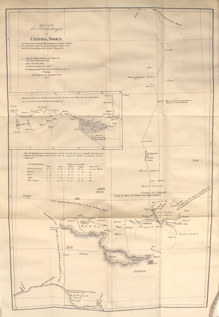
"Uebersicht der Entdeckungen in Central Africa... [in] Neue Allgemeine Geographische und Statistische Ephemeriden…", Geographisches Institut

Subject: Central Africa

Period: 1825 (dated)

Publication:

Color: Black & White

Size:
12.8 x 19 inches
32.5 x 48.3 cm
Download High Resolution Image
(or just click on image to launch the Zoom viewer)

This is a reduced, German edition of Map of the Travels and Discoveries made in Northern & Central Africa, by Dr. Oudney, Major Denham & Captn. Clapperton R.N., in the years 1822, 3, & 4 published in the Narrative of Travels and Discoveries in Northern and Central Africa…. The British trio was sent to the region to establish trade links in Western Africa and to specifically trace the route of the Niger River. The map depicts their course from Tripoli, across the Sahara Desert, to the kingdom of Bornu. While they were the first documented Europeans to visit Lake Chad and proved that it was not the source of the Niger, they were unable to trace the river's course due to local leaders' concerns that they would interfere with the local slave trade. Includes a 64-page article on their journey. Map is still bound in the 490-page text. Octavo, hardbound with marbled boards.

References:

Condition: A

Condition code is for the map which is crisp and bright with just a few tiny spots and a binding trim confined to the left blank margin that has been closed with archival tape on verso. Deckled text has some light toning along sheet edges. Covers are moderately rubbed with the bottom corners chipped (B).

Estimate: $140 - $170

Sold for: $100

Closed on 11/19/2014

Archived