Catalog Archive
Auction 151, Lot 59

"Totius Americae Septentrionalis et Meridionalis Novissima Repraesentatio quam ex Singulis Recentium Geographorum Tabulis Collecta Luci Publicae Accomodavit", Homann, Johann Baptist

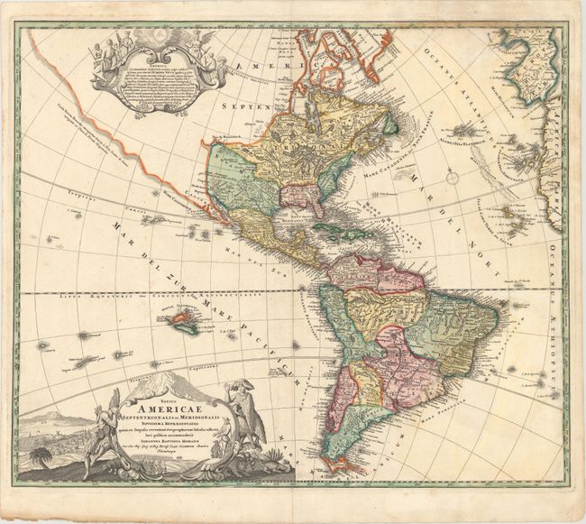
Subject: Western Hemisphere - America

Period: 1710 (circa)

Publication: Atlas Novus Terrarum Orbis Imperia…

Color: Hand Color

Size:
22.8 x 18.9 inches
57.9 x 48 cm
Download High Resolution Image
(or just click on image to launch the Zoom viewer)

This attractive map is a revision of the elder Homann's 1710 map of the Americas. After his death in 1724, his son (Johann Christoph Homann) re-engraved the plate to correct the western coastline of North America, shown here extending very far west and north, with very little detail. California is no longer shown as an island, although the remnants of the interior sea can be seen near the Pais de Moozemleck where a river nearly connects with the Mississippi River system, hinting at the possibility of a Northwest Passage. The Great Lakes are taking shape, being actively explored by the French fur traders and the Hudson Bay Company. The Solomon Islands are prominently placed in the Pacific, considerably too far to the east. The map is decorated with two large pictorial cartouches, the one at top shows natives worshipping a fearsome demon at the right, while at left they listen placidly to a priest. The lower cartouche also features the landscape and native fauna.

References: McLaughlin #175; Tooley (Amer) p. 129 #79; Portinaro & Knirsch #109.

Condition: B+

A fine impression on watermarked paper with light soiling, a crease adjacent to centerfold, and a damp stain at top right.

Estimate: $1,400 - $1,700

Sold for: $850

Closed on 11/19/2014

Archived