Catalog Archive
Auction 151, Lot 449

Scarce Chart Depicting Updated Coastline of Greenland

"[Pascaart van Europa op Wassende Graaden door Dirck Rembrantsz van Nierop]", Doncker, Henrick

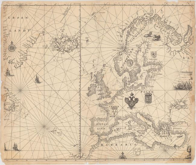
Subject: Europe & North Atlantic

Period: 1690 (circa)

Publication:

Color: Black & White

Size:
23.7 x 19.9 inches
60.2 x 50.5 cm
Download High Resolution Image
(or just click on image to launch the Zoom viewer)

This is the central portion of an extremely scarce oversized copperplate chart of Europe, extending to include the majority of the North Atlantic. The full plate was listed in an advertisement in Doncker's Nieuw Groot Stuurmans Straetsboeck, published in 1664, and was to be printed on either vellum or paper. The advertisement explains that the chart would be fit to put in a golden frame as a "jewel" or prize decoration in the home. Only one example of the full chart is known to be in existence, a hand-colored vellum example at the Maritime Museum in Rotterdam. As the oversized chart would not fit in a folio atlas, Doncker masked different portions of the chart in order to print the chart on paper for several of his atlases. The British Library has an example of this masked chart in a Doncker atlas published in 1696, Nieuwe Groote Vermeerderde Zee-Atlas ofte Water-Werelt. However, the chart in the British Library exemplar is shifted slightly to the west and includes a title added below the ships at bottom left: "Pascaert van het Westerlyckste Deel van Europa." This is the only known copy of this atlas. Another example of the masked chart exists in a 1693 Doncker atlas in the Biblioteca Nacional in Madrid, with the chart shifted farther north.

Doncker's oversized sea chart is largely based on Jacob Aertsz. Colom's four-sheet chart published in 1651, Der Groote Noord Zee Wassende Grade Pas Caart, which extends further north and west than Doncker's chart (see Burden #302). The coastlines of Europe and northern Africa are filled with place names, while the coats of arms of various nations are placed within the interior. In Scandinavia is a charming depiction of horned sheep in a pasture. Along the right edge of the sheet are the beginnings of an elaborate vignette and the title cartouche.

The Prime Meridian is based in the Canary Islands. Iceland, Jan Mayen Island, and the mythical Enchuyser Eylant are depicted just west of the Prime Meridian in the North Atlantic, with numerous place names and depth soundings surrounding Iceland. This chart also gives good detail of Greenland, which has a partially delineated coastline to the south and a projected coastline to the northeast. Interestingly, there are significant differences between this chart and all of Doncker's other charts representing Greenland, Iceland, and Davis Strait, published between 1659 and his death in 1699. This chart gives two additional place names in Iceland: Lokula Haske in the south and Suer in the east. In addition, the shape of Greenland and place names along the coastline are starkly different in this map versus his other works. This map has place names concentrated on the western coast (partially truncated in this example), and depict the island with a more accurate shape. In contrast, Doncker's other charts of Greenland show the island with a pointy southern tip that slants to the southwest, with several large islands at the southern end. These differences clearly show that this chart was based on Colom's chart, whereas Doncker's other maps representing Greenland were based on Pieter Goos' chart of Greenland, Iceland, and Davis Strait, first published in 1650 (Pascaerte van Groen-Landt), which itself was based on Theunis Jacobsz' chart of Greenland.

References: cf. Shirley (BL Atlases) M.DON-2c #3.

Condition: B

A nice impression with minor soiling and light damp stains at right and left. There are 2" centerfold separations at top and bottom, as well as several short tears and one long tear extending from northern Africa to Ireland that have been closed on verso with archival materials.

Estimate: $1,400 - $1,800

Sold for: $4,250

Closed on 11/19/2014

Archived