Catalog Archive
Auction 151, Lot 368

"A New Map of the Island of Cuba with Correct Plans of All the Principal Ports and Harbours It Contains", Gibson, John
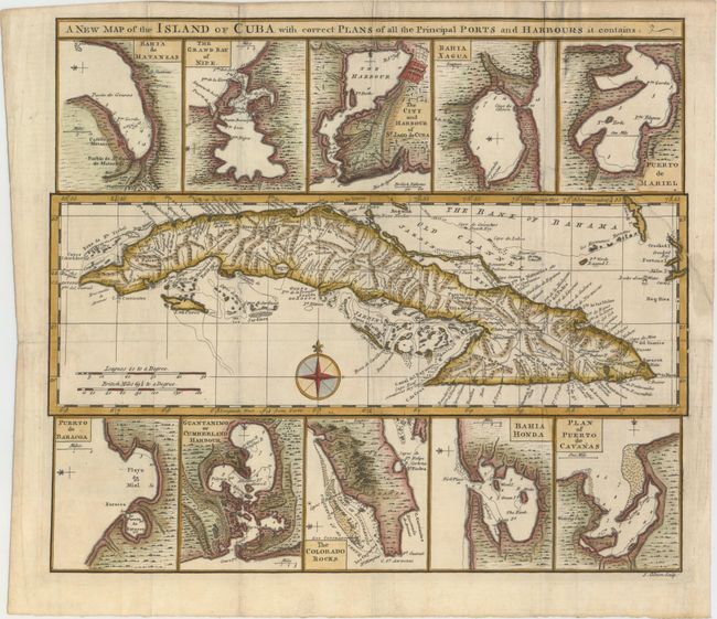
Subject: Cuba

Period: 1760 (circa)

Publication: Universal Museum

Color: Hand Color

Size:
13.6 x 11.8 inches
34.5 x 30 cm
Download High Resolution Image
(or just click on image to launch the Zoom viewer)

This handsome sheet contains a map of Cuba surrounded by 10 small insets of the principal ports and harbors of the island. The map of Cuba shows towns, roads, rivers and mountains, with some navigational information in the surrounding waters. The inset maps depict Matanzas, Nipe Bay, Santiago de Cuba, Cienfuegos, Mariel, Baracoa, Guantanamo, Cape San Antonio, Bahia Honda, Cabanas.

The Universal Museum was a very short-lived British periodical published between 1762 and 1764. Maps from this publication are rarely seen on the market and we can find no record of this map except in a few institutional collections. It would be an important addition to any Cuban map collection.

References: Jolly #UMUS-9.

Condition: B+

A strong impression, issued folding, now pressed on watermarked paper with minor archival repairs to a few short fold separations. There is a binding tear that extends 3.5" into map at right that has also been archivally repaired.

Estimate: $180 - $220

Sold for: $275

Closed on 11/19/2014

Archived