Catalog Archive
Auction 151, Lot 109

"Amplissimae Regionis Mississipi Seu Provinciae Ludovicianae…", Homann, Johann Baptist

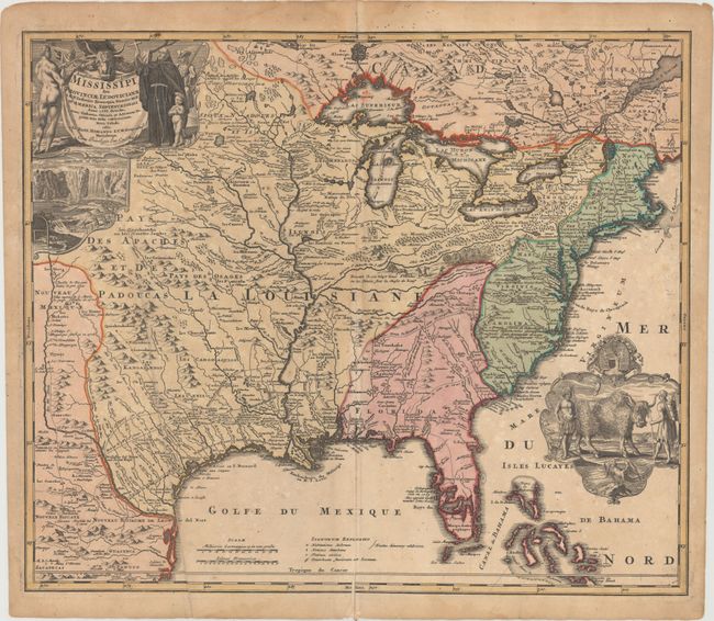
Subject: Colonial Eastern United States & Canada

Period: 1720 (circa)

Publication:

Color: Hand Color

Size:
22.8 x 19.3 inches
57.9 x 49 cm
Download High Resolution Image
(or just click on image to launch the Zoom viewer)

A striking map based on Delisle's landmark map of 1718, but covering a slightly larger area. It focuses on the Mississippi River Valley interior and Great Lakes, also detailing the Gulf Coast region, where the Mission de los Teyas is noted in present-day Texas. The map is splendidly adorned by vignettes of a buffalo and Native Americans in a cartouche filling the Atlantic, and a beaver colony at Niagara Falls under the title cartouche at upper left. Also depicted in the title cartouche is Father Louis Hennepin who explored the Great Lakes region and claimed to have reached the mouth of the Mississippi. The routes of Hennepin, de Soto and other explorers are traced in the map.

References: McCorkle #720.1; Wheat (TMW) #144; Goss (NA) #49; cf. Cumming (SE) #170.

Condition: B

Original color with light toning and scattered foxing, a centerfold separation that enters 1.75" into the image at bottom, and a long printer's crease at left.

Estimate: $1,500 - $1,800

Sold for: $1,500

Closed on 11/19/2014

Archived