Catalog Archive
Auction 150, Lot 710

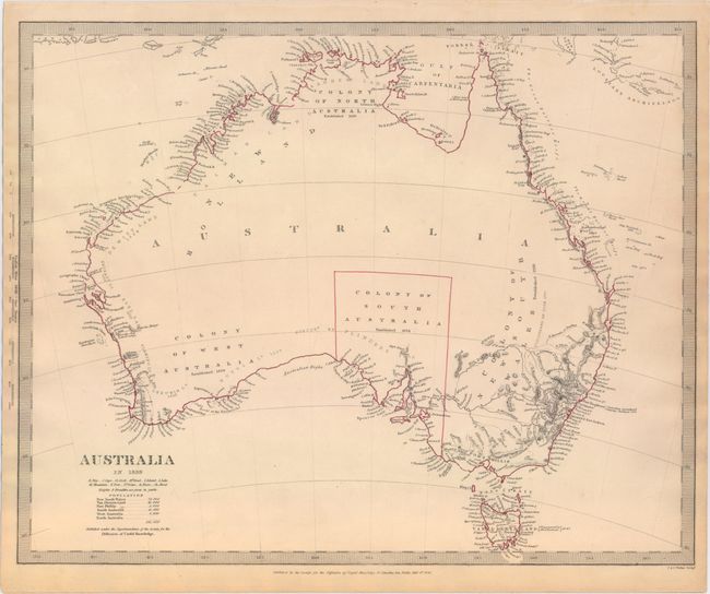
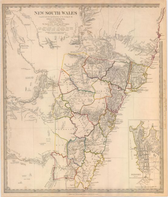
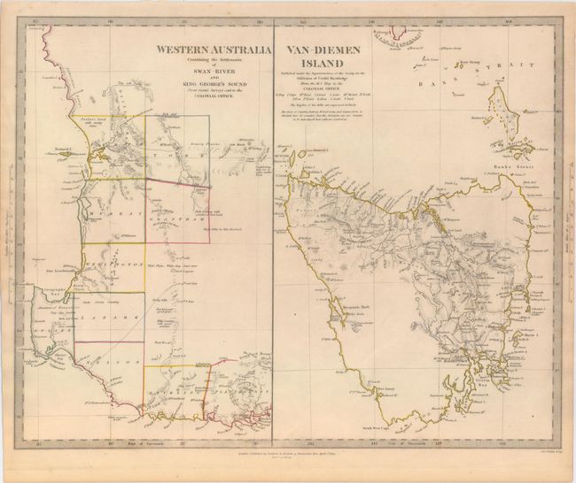
"[Lot of 3] Australia in 1839 [and] New South Wales... [and] Western Australia Containing the Settlements of Swan River and King George's Sound...[on sheet with] Van-Diemen Island", SDUK Society for the Diffusion of Useful Knowledge

Subject: Australia

Period: 1833-40 (dated)

Publication:

Color: Hand Color

Size:
See Description
Download High Resolution Image
(or just click on image to launch the Zoom viewer)

The beginning of the nineteenth century saw a period of rapid market growth and innovation in the map publishing world. Increased literacy and public interest in new frontiers and colonies overwhelmed the market because it was oriented toward the small, affluent market of the previous century. With the intent to fill this void, The Society for the Diffusion of Useful Knowledge (SDUK) was founded in 1828 in London, by Lord Brougham and a group of men dedicated to the education of the aspiring working class and the Utilitarian ideal of 'Knowledge is Power.' The society produced an array of education materials, but the series of maps was one of their most successful ventures. A number of engravers and printers were used to produce the maps, which eventually exceed 200 sheets, and continued to be published after the Society as a whole ceased to function.

A. Australia in 1839, dated 1840 (15.6 x 12.6"). Crisply engraved chart with terrific coastal detail with scores of place names and a virtually blank interior. Major discoveries of Cook, Tasman and Flinders are identified. Each colony is named and notes the date of establishment, but none have their boundaries delineated save the "Colony of South Australia." Locates the small towns of Sydney, Adelaide, Perth, and Hobart on Tasmania, here Van Diemen Land. The only settlement in the vicinity of today's Melbourne is Cowie on the west side of Port Phillip near today's Geelong. Notation at Port Stephens: "Australian Agricultural Company, Chartered 1824." The population of the whole region is noted as 141,000. A simple, but elegant map with a keyboard style border.

B. New South Wales, dated 1833 (13.5 x 15.6"). An incredibly detailed map of the thriving colony compiled "From the M.S. maps in the Colonial Office, the Surveys of the Australian Agricultural Company, and the Routes of Allan Cunningham." The counties are colored in outline and the eastern part of the map is detailed with topographical features and interesting notations. Large inset plan of "Sydney from the New South Wales Almanack" marks important buildings including Bathing Houses, Botanic Garden and the Albion Brewery, established in 1827.

C. Western Australia Containing the Settlements of Swan River and King George's Sound... [on sheet with] Van-Diemen Island, dated 1833 (15.6 x 12.3"). Two maps on one sheet. The first covers from Perth and the settlements along the Swan River to St. George's Sound. The other half covers all of Tasmania and the Bass Strait with interesting detail of the sparsely settled regions.

References:

Condition: A

Original outline color with faint toning and soiling along sheet edges.

Estimate: $350 - $450

Sold for: $220

Closed on 9/17/2014

Archived