Catalog Archive
Auction 150, Lot 69

Valck's Uncommon Map of the Americas in Full Original Color

"L'Amerique Septentrionale & Meridionale Divisee en ses Principales Parties, ou sont Distingues les uns des Autres les Estats…", Valck, Gerard

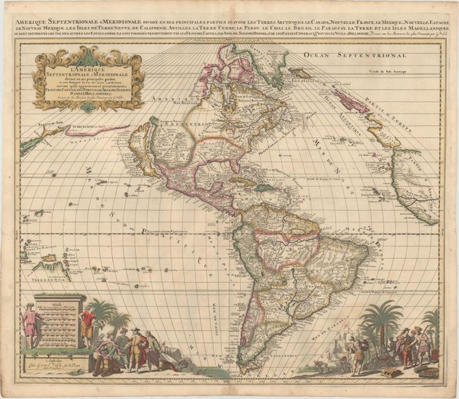
Subject: Western Hemisphere - America

Period: 1695 (circa)

Publication:

Color: Hand Color

Size:
22.4 x 18.1 inches
56.9 x 46 cm
Download High Resolution Image
(or just click on image to launch the Zoom viewer)

This beautiful map of the Americas is derived from Jaillot's map of North America in 1674, which in turn drew on the cartography of Nicolas Sanson. California appears as an island and the Great Lakes are open-ended in the west. The R. del Norte (Rio Grande) rises from a large lake in Apache country and flows incorrectly into the Mer Rouge between the mainland and the island of California. A spurious lake is depicted in the Appalachian Mountains just above Floride Francoise. In the North Pacific several coastlines stretch toward Asia with Japan appearing on the left border. In the South Pacific Terre de Quir and the Salomon Islands are depicted. The mythical Lac Parime appears in South America with the golden city of Manoa el Dorado on its shore. The bottom of the map is richly embellished with two great scenes of Europeans trading with natives. The scene on the left incorporates eight distance scales into a large monument. The title cartouche is rendered in the flourishing style that gained popularity at the turn of the seventeenth century. A second French title is in the top margin.

References: Burden #713; McLaughlin #153.

Condition: B+

A nice impression with full original color, minor offsetting, and a professionally repaired centerfold separation that enters 1/2" into map at bottom. There are two short cracks at bottom left caused by the oxidation of the green pigment, both of which have been professionally reinforced on verso.

Estimate: $1,600 - $1,900

Sold for: $1,150

Closed on 9/17/2014

Archived