Catalog Archive
Auction 150, Lot 298

Rare 1861 Colton Issue

"Colton's Rail-Road and Military Map of the United States Mexico, the West Indies &c.", Colton, Joseph Hutchins

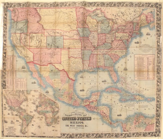
Subject: United States, Mexico & Central America

Period: 1861 (dated)

Publication:

Color: Hand Color

Size:
38.7 x 32.3 inches
98.3 x 82 cm
Download High Resolution Image
(or just click on image to launch the Zoom viewer)

This early, rare separately issued map of the United States and Mexico is based upon the 1859 Butterfield/Colton "Map of the United States and Mexico." "Military" has been added to the title, but the states are not color-coded to indicate Free or Slave State as was the case with the 1862 Colton edition. This suggests the map was issued just prior to the outbreak of the Civil War.

Geographically, the western territories are shown in evolving configurations with Arizona shown along the bottom of New Mexico Territory. Washington is depicted in an inverted "L" shape and Nebraska has a long panhandle. To Nebraska’s north is a huge Dakota Territory encompassing present-day Montana, but its name is confined to east of the Missouri River. A large inset at lower left, Colton’s Map of the Americas, Africa and a Portion of Europe…, depicts the routes of explorers. Statistics indicating free and slave population by state are shown in the Pacific (not on the Butterfield map) and a table of distances occupies the Atlantic. Surrounded by an elaborate floral border.

References: cf. Rumsey #3484 & #2554.

Condition: B

Issued folding and backed with Japanese tissue to reinforce and repair numerous small fold separations resulting in very minor loss of image and a 11" tear at left that extends from the census statistics north to Utah. Light toning along the folds and a few spots of foxing.

Estimate: $1,200 - $1,500

Sold for: $750

Closed on 9/17/2014

Archived