Matching Set in Full Original Color
"[Lot of 5] Nova Orbis Tabula, in Lucem Edita [and] Novissima et Accuratissima Septentrionalis ac Meridionalis Americae Descriptio... [and] Totius Africae... [and] Accuratissima Totius Asiae Tabula... [and] Nova et Accurate ... Europae Descriptio", Wit, Frederick de
Subject: World & Continents
Period: 1690 (circa)
Publication:
Color: Hand Color
Size:
22.7 x 19.2 inches
57.7 x 48.8 cm
This is a matching set of maps of the world and continents by noted Dutch map publisher, Frederick de Wit. Size varies slightly.
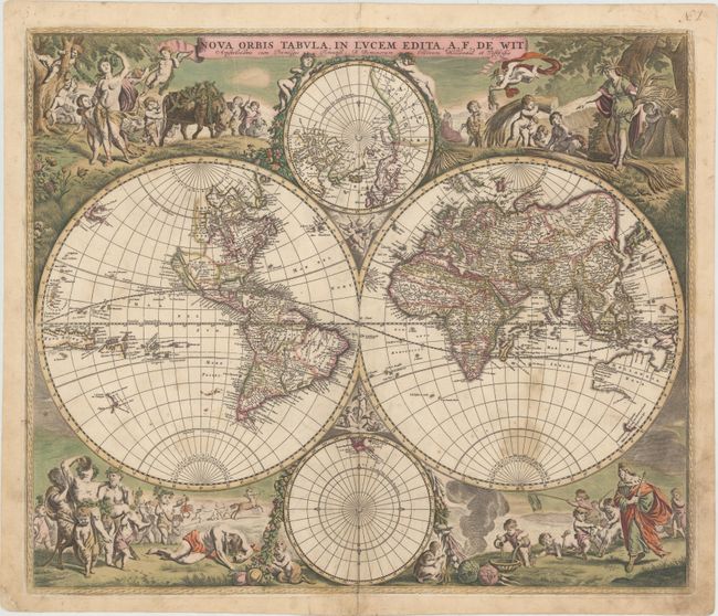
A. Nova Orbis Tabula, in Lucem Edita. This is one of the most attractive double-hemispherical world maps of the late seventeenth century. The corners are filled with images of the seasons, the zodiac, and the elements, all combined within four well-composed vignettes. At top left is a personification of Spring, who also represents Virgo, with the element of Air billowing her robes. The bull of Taurus and the ram of Aries are shown to the right. The top right vignette represents Autumn, with the shore in the background illustrating the element Water. A putti holds a crab representing Cancer, and another holds the lion of Leo. The twins of Gemini flank the inset of the North Pole at top. The lower left scene presents Summer and Earth with a wine-imbibing Bacchus and a scene of drunkenness The signs for Scorpio and Libra are held by two followers, while Sagittarius gallops in the background. Winter holds court in the final vignette, with the element of Fire shown to the left. Aquarius is represented by a child pouring water into a basin. A group of raucous children in the background hold a goat representing Capricorn and a fishing pole with the double fish of Pisces.
In North America, the Great Lakes appear as one large semi-circle with an open western end, and the island of California is shown on the Briggs model with a flat northern coast, and a portion of Anian appears in the Pacific Northwest. South America has the mythical L. Parime astride the equator, with the imaginary golden city of Manoa on its shores. Asia displays a Japan with an oversized Iedso (Hokkaido) shown on the map of the Western Hemisphere. A partial coastline for Australia is shown, and both New Zealand and Tasmania are indicated by only one stretch of coastline. The inset of the North Pole shows Hudson Bay with two southern bays, and the inset of the South Pole is nearly blank save for the very tip of South America and Tierra del Fuego. This is the second plate with cherubs in the cusps and the appearance of Nova Guinea and Quiri Regio in the western hemisphere. Ref: Shirley #451. Condition: There are some stains in the southern hemisphere, a few minor creases, and a professionally repaired 1" tear east of Brazil.
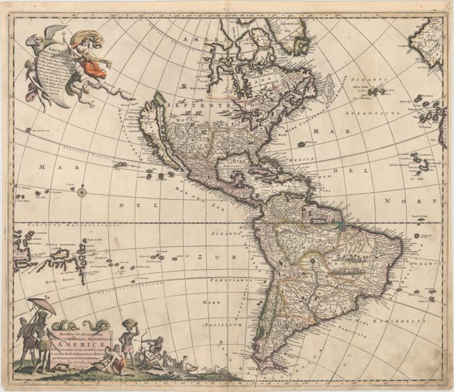
B. Novissima et Accuratissima Septentrionalis ac Meridionalis Americae Descriptio, Multis Locis Recentibus Aucta et Correcte Divisa in Omnes Partes Hodiernas. This is the seventh state of this great map of the Americas, originally engraved circa 1675, and updated with the addition of New Guinea, the Solomon Islands, and Quiri Regio, Fretum Aniani and Terra Esonis. While the decorative features follow Visscher, the cartography is largely based on Sanson. California is an Island, the Great Lakes are open-ended in the west, and the R. del Norte flows from a large western lake and empties into the sea between the mainland and California, labeled Mare Vermio. In South America, the mythical lakes of Parime Lacus and Xarayes are shown, along with vignettes of a battle scene and a village in the Brazilian interior. The pictorial title cartouche contains scenes of gold panning, hunting and a native chief standing beneath an umbrella. The only change De Wit made was that the chief is standing on the left rather than on the right as in Visscher's composition. The top cartouche depicts angels struggling with a devil for the soul of a Native American. Ref: Burden #465; McLaughlin #49, Tooley (America) p.120 #33.
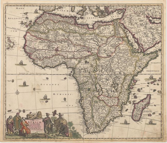
C. Totius Africae Accuratissima Tabula, Denuo Correcte Revisa, Multis Locis Aucta, in Partes tam Maiores quam Minores Divisa. The information contained in this beautiful map of the African continent is typical of the late 17th Century. The Nile appears according to the ancient pattern of Ptolemy, arising from the two lakes of Zaire and Zafflan. De Wit's depiction of the southeastern coast includes numerous deep inlets and several rivers and lakes at the southern tip not seen on other maps of the period. The kingdom of Monomotapa extends as far south as the Rio de Infante and there are few names in the interior of the Cape. The fictitious N. I. de Sta. Helena appears in the South Atlantic. The interior is decorated with elephants, ostriches, monkeys, lions and rhinoceros, and seven small ships sail in the oceans. The well-engraved title cartouche features Moors and Africans with a child seated on an elephant and two lions perched atop the cartouche. This popular map was copied by several other cartographers including Danckerts and De Ram. This is the fifth state. Ref: Betz #114.5; Norwich #48. Condition: There is a professionally repaired tear that enters 2" into cartouche at bottom, and a few tiny abrasions.
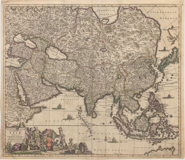
D. Accuratissima Totius Asiae Tabula in Omnes Partes Divisa, de Novo Correcta, ac in Lucem Edita. This handsome, large map of the continent and East Indies shows the extent of European knowledge of the region. It is vividly rendered with good detail throughout the south and south east, due to the surveys of the Dutch East India Company, while northern and central Asia is filled mostly with mountains, deserts and forests. The work of the Jesuit missionaries is reflected in the well-documented region of China. The large title cartouche includes a busy scene including traders with their exotic cargo. Ref: Yeo #59. Condition: There is a professionally repaired tear that extends from the centerfold to the Black Sea, and a chip in the bottom left corner has been repaired, with image expertly replaced in facsimile.
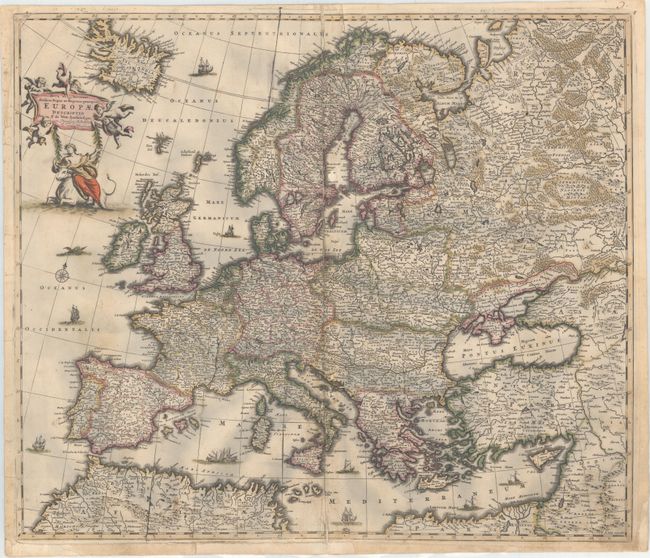
E. Nova et Accurate Divisa in Regna et Regiones Praecipuas Europae Descriptio. Finely engraved large map of Europe with the characteristic detail of this prominent Dutch cartographer. It is richly ornamented with a variety of ships sailing the seas, a compass rose, a sea monster, Europa shown riding Zeus in the form of a bull, and several putti holding the title banner aloft. Condition: Several tears adjacent to the centerfold (between 1" and 2" in length) have been archivally repaired. There are a few small abrasions, and some small chips and tears in blank margins have also been archivally repaired. There are some bluish shadows that appear throughout the map that are caused by our scanner, and do not appear on the map.
References:
Condition: B
All maps are in full original color on watermarked paper with light to moderate soiling, and professionally repaired centerfold separations at bottom. See description above for additional details.