"[Lot of 2] North America [and] North America",
Subject: North America
Period: 1780-1800 (circa)
Publication:
Color: Hand Color
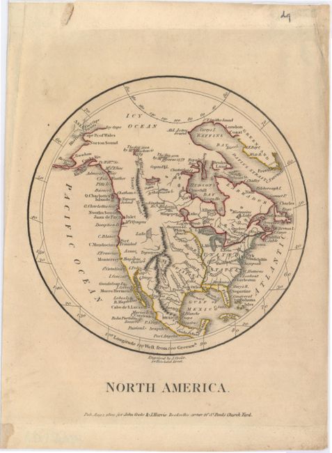
A. North America, by John Cooke & John Harris, dated 1800 (5.6 x 6.3"). The United States is shown with its western boundary on the Mississippi River on this detailed circular map of North America. Several rivers and cities such as San Diego, Cenis, Santa Fe, and the mythical Quivira are identified in the land west of the Mississippi, here called Louisiana. The Great Salt Lake appears labeled only as Lake. Alaska is fairly well formed, but still an early configuration. The Stony Mountains are noted in Canada, but do not extend into what is now the western U.S. Notes in the upper reaches of Canada read, "The Sea seen by Mackenzie 1789" and "The sea seen by Mr. Hearne 1779." Condition: On watermarked paper with marginal soiling and remnants of hinge tape on the verso.
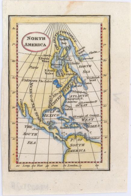
B. North America, by Anonymous, circa 1780 (2.8 x 4.3"). This small yet striking map of the continent extends from north of Baffin Bay down to the northern tip of South America. The United States is confined to the east of the Mississippi and the only city identified is Philadelphia. Land west of the Mississippi is identified as Mexico or New Spain. The blank, unexplored northwest is referred to as Parts Unknown. Condition: There is a small stain in the upper blank margin, else fine.
References:
Condition: A
See description above.