Catalog Archive
Auction 149, Lot 751

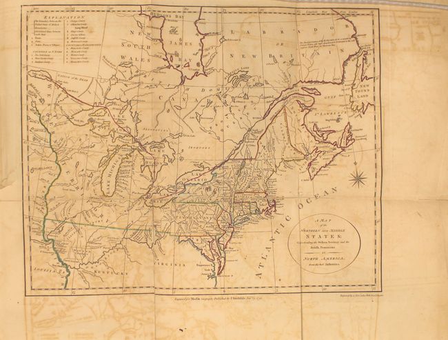
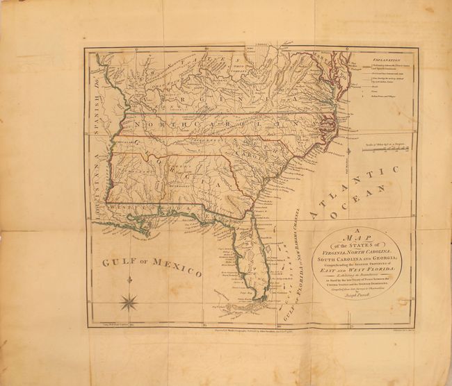
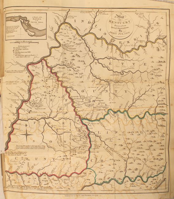
Includes the Stockdale Edition of Filson's Map of Kentucky

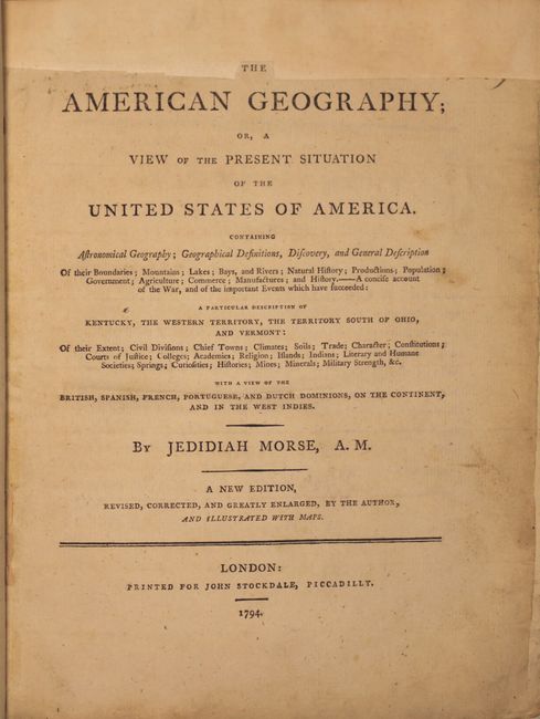
"The American Geography; or, a View of the Present Situation of the United States of America...", Morse, Jedidiah (Rev.)

Subject: Geography Books

Period: 1794 (published)

Publication:

Color: Hand Color

Size:
9.2 x 11.5 inches
23.4 x 29.2 cm
Download High Resolution Image
(or just click on image to launch the Zoom viewer)

With the folding maps: "A Map of the Northern and Middle States; Comprehending the Western Territory and the British Dominions in North America from the Best Authorities;" "A Map of the States of Virginia, North Carolina, South Carolina and Georgia; Comprehending the Spanish Provinces of East and West Florida;" and "A Map of Kentucky Drawn from Actual Observations." Rebound in quarter faux leather over red marbled boards. Quarto, 642 pp. (deckled edges) with three folding maps. This is the John Stockdale edition published from London.

Of particular interest is the rare Kentucky map which was first produced by Filson in 1784 and here republished in 1793. The map extends from the Ohio River in the north to the Cumberland River in the south and shows three counties: Fayette, Jefferson and Lincoln. It is filled with notations including "a bloody battle fought here" and "the large Bones are found here", settlements, the river system and topography. Includes an inset at top "A Plan of the Rapids, in the River Ohio" which was not on the 1784 edition. John Filson (1753 - 1788) was the first Historian of Kentucky. Moving from Pennsylvania about 1782, he settled in Lexington where he divided his time between teaching and surveying land claims. He wrote The Discovery, Settlement and Present State of Kentucke in 1784. In 1788, while on a surveying expedition near the Great Miami River, he disappeared when the party was attacked by Shawnee Indians.

The second map, by Joseph Purcell, is an uncommon, early depiction of the Southeast and shows a well defined New State of Franklin, within the borders of North Carolina. In 1785, settlers in present-day western North Carolina and eastern Tennessee organized a state government to be named in honor of Benjamin Franklin. Congress turned down their appeal but the state maintained a legislature and governor until 1788. This ephemeral state appeared on a small number of maps into the early part of the 19th century. The map shows early settlements, including a Moravian Settlement in North Carolina, and the Cumberland Settlements in present-day Tennessee. The map also notes native tribes and various Bounty Land Grants lands along the upper Mississippi River.

The third map of the Northern and Middle States describes the area from Maine (Province of Main), south to Virginia. Lesser detail extends west to the Great Lakes and the confluence of the Ohio and Mississippi Rivers, and north to eastern Canada up to James Bay. There are several Bounty Land Grants including Genl. Clarks, Donation Lands from the Commonwealth of Virginia, and Ohio Company in Ohio, and Wabash Company, New Jersey Company, and Illinois Company in Illinois. This is the first edition, with information taken from Amos Doolittle's map of the same title.

References: Wheat & Brun #149, #491, cf. 631.

Condition: B

Condition code is for the maps which have moderate to heavy offsetting with numerous fold separations closed on verso with old paper and archival tape. Text is good with some light scattered foxing, and the top blank margin of the title page has been replaced with old paper. New binding is excellent.

Estimate: $4,000 - $5,000

Sold for: $2,500

Closed on 5/21/2014

Archived